

|
This 2006 photo shows the Honore Mercier Bridge (QC 138) looking south from the LaSalle borough of Montreal. Note the raised profile of the truss span over the St. Lawrence Seaway relative to the much longer arch span. (Photo by Laura Siggia Anderson.) |
||

|
A NEW HIGHWAY CROSSING FOR THE SOUTH SHORE: As early as 1910, officials on the South Shore sought a new automobile crossing to supplement the existing Saint Laurent Railway Bridge between the city of LaSalle on the North Shore (now a borough of Montreal) and the Kanhawake Indian Reservation (then called Caughnawaga) on the South Shore. Denied permission to attach outboard roadways by the Canadian Pacific, which owned the bridge, local officials lobbied the province to build an automobile-only span. |
||
|
Honore Mercier, the provincial minister of lands and forests and a representative from Chateauguay, expressed concern about the absence of a vehicular connection and the lack of a provincial commitment to build such a span: |
||
|
After studies were conducted in the spring and summer of 1928, the Quebec Department of Public Works determined in a report released that October that a new fixed automobile crossing between LaSalle and Kahnawake would cost C$1.8 million, less than the C$2.3 million it would have cost to add roadways to the Saint Laurent Railway Bridge (as was done with the Victoria Bridge [QC 112]). Under the auto-only bridge option, the province would retain ownership of the bridge, while under the railway bridge option, the Canadian Pacific Railroad would have kept ownership of the bridge. |
||

|
This vintage postcard shows the Honore Mercier Bridge as originally built. Note the single-span arch bridge and the gently-sloping southern approach to the right of the span. The southern approach was rebuilt in the late 1950s, while the main river span was twinned in the early 1960s. (Postcard from Evelyn Theriault's "A Canadian Family" site. |
||
|
DESIGN AND CONSTRUCTION OF THE ORIGINAL BRIDGE: The original bridge was comprised of 12 spans totaling 889 meters (2,918 feet) in length: the main 122-meter-long (400-foot-long) steel-arch span, two side spans flanking the steel arch span; and nine through-truss spans of varying length extending north from the steel arch superstructure to the LaSalle shoreline. There was a single 8.1-meter-wide (26.5-foot-wide) roadway to accommodate two lanes of vehicular traffic (one in each direction), flanking by a 1.2-meter-wide (four-foot-wide) walkway. |
||
|
On the north end of the bridge was a 91-meter-long (300-foot-long), five-span viaduct connecting to the street network in LaSalle; this approach was built with a 3.5% approach grade. Connecting to the South Shore was a 381-meter-long (1,250-foot-long), 14-span viaduct connected to an improved highway (now part of QC 132); this approach was built with a 2.5% grade. |
||

|
This 2008 photo shows the westbound / southbound Honore Mercier Bridge (QC 138) approaching the steel arch span over the main St. Lawrence River. (Photo by Doug Kerr, www.gribblenation.com.) |
||
|
RAISING THE BRIDGE FOR THE SEAWAY: On September 22, 1954, the federal government announced plans to build a new southern approach to the Mercier Bridge to accommodate the St. Lawrence Seaway, which was in its early stages of construction along the South Shore. Instead of building a lift span as some officials had suggested, the federal government, as part of its takeover of the southern half of the Mercier Bridge (the northern half was to remain under Quebec jurisdiction) proposed eliminating the low-level viaduct approach to Kahnawake and building a high-level Warren truss bridge over the Seaway. At the same time, the project would add a second roadway over the Seaway, with the provision for future expansion north of the Seaway. |
||
|
The federal government awarded contracts in August 1956 and January 1957 for the project, which included construction of a two-lane temporary span and a new multi-level interchange with QC 132 in Kahnawake. In May 1957, workers demolished the 14 spans of the old southern approach. |
||

|
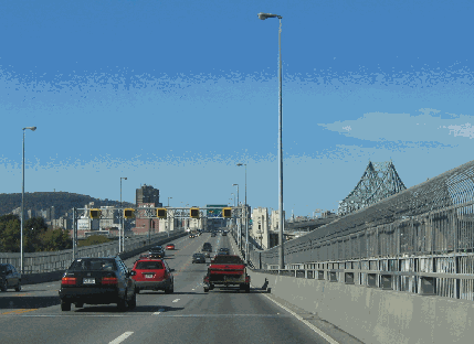
This 2008 photo shows the westbound / southbound Honore Mercier Bridge (QC 138) approaching the high-level Warren truss span over the St. Lawrence Seaway. (Photo by Doug Kerr, www.gribblenation.com.) |
||
|
THE BRIDGE'S ROLE IN THE OKA CRISIS: For a seven-week period in the summer of 1990, members of the Mohawk tribe in Kahnawake seized control and barricaded the Mercier Bridge in sympathy with their fellow Mohawk members in the Kanesatake Reservation, whose protest of a golf course expansion in Oka led to a shooting match and the death of a Quebec Provincial Police (Surete du Quebec) officer. The 55,000 commuters who used the Mercier Bridge each day had to take a lengthy detour to the already congested Champlain Bridge (A-10, A-15, and A-20), and the two-hour commutes that resulted further strained relations between Chateauguay and Kahnawake residents. |
||
|
The bridge reopened toward the end of the Oka crisis in September 1990 after minor repairs. Although tensions have subsided, the span was the site of peaceful protests that closed the bridge for a few hours in 2006 and 2007, when members of the Mohawk tribe hoisted "warrior" and "confederacy" flags atop the bridge. (The flags were replaced hours later by Quebec flags just days after the 2006 protest.) |
||

|
This 2008 photo shows the eastbound / northbound Honore Mercier Bridge (QC 138) approaching the steel arch span. The two roadways diverge at the steel arch spans and do not rejoin each other until EXIT 1 (Airlie Street / Newman Boulevard) on the Mercier Autoroute in LaSalle. (Photo by Scott Steeves, www.canhighways.com.) |
||

|
PART OF A NEWLY EXTENDED A-13: The A-13 designation should be extended south along the Mercier Autoroute and Mercier Bridge (QC 138) south to Kahnawake, then east along the present route of QC 132 to the stub end of the current A-30, replacing the A-730 now proposed for the stub. Service roads would be built along the present alignment of QC 132 to serve homes and businesses in the Kahnawake Reservation. Although this project could be done with a minimal amount of displacement, it is unlikely this project ever would be undertaken given the history of tensions in the area. |
||

|
Type of bridge |
||
|
Steel arch and through truss |
||

|
SOURCES: "Farm Credits Act Is Enacted by Legislature," The Montreal Gazette (3/20/1928); "New Caughnawaga Bridge Is Assured," The Montreal Gazette (10/16/1928); "Bridge Bill Is Held in House," The Ottawa Citizen (5/30/1930); "Order for Dominion Bridge Looms on Horizon," The Financial Post (1/23/1932); "Bridge Work Advanced," The Montreal Gazette (8/23/1933); "Bridge Roadway Is Near Completion," The Montreal Gazette (5/12/1934); "New River Bridge Opened to Traffic," The Montreal Gazette (6/23/1934); "Colorful Scenes As Caughnawaga Span Inaugurated," The Montreal Gazette (7/12/1934); "New St. Lawrence Bridge Opened," The New York Times (7/12/1934);"Quebec Takes Over Toll Bridge Firm," The Montreal Gazette (5/01/1944); "Assured--But Not Told" (Op-Ed), The Montreal Gazette (11/03/1954); "Mercier Bridge Contracts Awarded," The News and Eastern Townships Advocate (8/30/1956); "Mercier Bridge Contract Awarded," The News and Eastern Townships Advocate (1/17/1957); "Bridge Approach Blasted" by Clayton Sinclair, The Montreal Gazette (5/09/1957); "Indians Lose Dispute with Seaway," The Ottawa Citizen (3/09/1957); "Constant Flow of Concrete Raises Piers for New High Approach to Mercier Bridge," The News and Eastern Townships Advocate (9/05/1957); "Steel Rises on Mercier Bridge Approach," The Montreal Gazette (1/01/1958); "Mercier Bridge Rebuilding," The Montreal Gazette (1/21/1958); "Traffic Snarl 'Worst'," The Montreal Gazette (7/14/1958); "Montreal Bridges Periled as an Explosives-Laden Barge Runs Wild in Lake," The Lewiston Daily Sun (10/13/1959); "New Approach for Mercier Bridge" by Don Johnson, The Montreal Gazette (7/31/1962); "Mercier Span To Be Ready by Labor Day" by Gordon Pape, The Montreal Gazette (7/07/1964); "Deluxe Traffic Jam Marks Reopening of Old Mercier Span" by Roger Bird, The Montreal Gazette (8/15/1964); "Dream Highways Soon a Reality," The Montreal Gazette (5/15/1965); "Jetport Link Alternate Proposed," The Montreal Gazette (9/14/1972); "Fury Rising in Quebec Over Mohawk Standoff" by John F. Burns, The New York Times (7/22/1990); "Barriers Are Down in Mohawk Dispute in Quebec," The New York Times (8/30/1990); "Quebec Bridge Mends, But a Town Is Scarred" by Chris Hedges, The New York Times (9/05/1990); "Two Lanes Open During Mercier Bridge Construction" by James Mennie, The Montreal Gazette (6/16/2008); "Bridges Between Montreal and South Shore Carry 86 Million Cars a Year," CBC News (1/09/2009); "A Bridge Too Dilapidated: Mercier Is a Third World Span" by Max Harrold, The Montreal Gazette (4/07/2009); Federal Bridge Corporation; Jacques Cartier and Champlain Bridges Incorporated; Ministère des Transports du Québec; Transport Canada; Christine Donais; Evelyn Theriault. |
||
|
HONORE-MERCIER BRIDGE LINKS: |
||
|
HONORE-MERCIER BRIDGE VIDEO LINK: |
||
|
HONORE-MERCIER BRIDGE CURRENT CONDITIONS: |
||

|
Autoroute des Souvenirs / Veterans Memorial Autoroute (A-20) Autoroute de l'Acier / South Shore Autoroute (A-30) |
||

|
Back to The Crossings of Metro Montréal home page. |
||
|
Site contents © by Eastern Roads. This is not an official site run by a government agency. Recommendations provided on this site are strictly those of the author and contributors, not of any government or corporate entity. |
||