
|
|
||
|
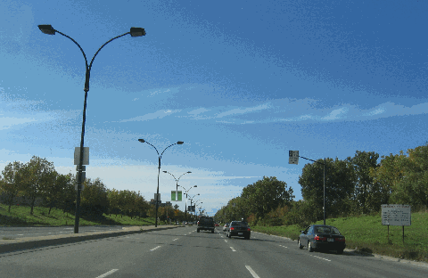
This 2015 photo shows the southbound A-19 (Papineau Expressway) at EXIT 5 (Boulevard de la Concorde) in Laval. This overpass was the site of a fatal collapse in 2006 that killed five and injured six. It was rebuilt in 2007, along with the nearby DeBlois Boulevard overpass that employed a similar design. (Photo by Dan Murphy.) |
||
|
Length: |
||
|
6.8 kilometers (4.2 miles); controlled-access section from Herni Bourassa Boulevard north to Dagenis Boulevard |
||
|
ANOTHER LINK FROM MONTREAL AND LAVAL TO THE NORTH: Conceived in the 1960s as a link between the Jacques Cartier Bridge (QC 134) and an expanded Mirabel Airport, the Papineau Expressway A-19) was to relieve congestion on the Laurentian Autoroute and Decarie Expressway, both of which comprise A-15. |
||
|
Construction of a short section of A-19, which included the cable-stayed Papineau-Leblanc Bridge over Riviere des Prairies (the largest cable-stayed bridge in North America when it was built), began in 1968 and was completed two years later. The Papineau-Leblanc Bridge connected the Montreal alignment of A-19 along Papineau Avenue with the highway's Leblanc Street alignment in Laval.This six-lane section stretched from Henri Bourassa Boulevard in the borough of Ahuntsic-Cartierville (Montreal) to EXIT 4 (Boulevard Levesque East) in the Duvernay section of Laval. The Papineau Expressway was extended north to EXIT 7 (QC 148 / St. Martin Boulevard East) in 1972, EXIT 8 (A-440 / Laval Expressway) in 1976, and EXIT 9 (Dagenais Boulevard East) in 1990. The expressway narrows to two lanes in each direction (from three) for the short section north of EXIT 8 as it becomes QC 335 (Papineau Avenue). |
||
|
Several weeks before the collapse, one eyewitness said there were "unusually large gaps and misaligned spacing in the deck-support structure underneath." About one hour before the collapse, an MTQ maintenance crew was sent to inspect the structure after reports that concrete had fallen from above, but the crew found no immediate danger. The MTQ did not close either A-19 or Boulevard de la Concorde; however, it did call for a full inspection of the bridge to be carried out the following Monday since no one was available that Saturday. |
||
|
Immediately after the collapse, officials closed A-19 from EXIT 4 (QC 148) north to EXIT 8 (A-440) to all traffic. Another overpass of similar design - the De Blois Boulevard bridge over A-19 - was closed indefinitely and tagged for replacement. Both the De la Concorde and De Blois overpasses were built in 1970 and were designed with a 70-year lifespan; the A-19 roadway beneath the bridges opened in 1972. Construction crews from the MTQ completed the demolition of the two overpasses on October 21, 2006 and reopened A-19 to traffic soon thereafter. |
||

|
This 2006 photo shows the southbound Papineau Expressway (A-19) at EXIT 8 (A-440 / Laval Expressway) in Laval. This photo was taken less than two hours after the Boulevard de la Concorde overpass collapse (at EXIT 5), and barricades shown in the distance were positioned promptly to detour traffic around the accident scene. (Photo by Laura Siggia Anderson.) |
||

|
This 2015 photo shows the Papineau Expressway (A-19) at the Papineau-Leblanc Bridge looking south toward Montreal. When it opened in 1970, the Papineau-Leblanc Bridge across the Rivieres-des-Prairies was the longest cable-stay bridge in the world. (Photo by Dan Murphy.) |
||
|
This 2013 photo shows the intersection of QC 335 (Papineau Avenue) and QC 344 (Adolphe Chapleau Boulevard) in the North Shore community of Bois-des-Filion. Since 2011, the Coalition for the Completion of Autoroute 19 has posted a billboard at this intersection to demand action on not ony construction of A-19, but also reserved bus lanes along the route. (Photo by Steve Anderson.) |
||
|
FINALLY� THE EXTENSION NORTH TO A-640 IS UNDERWAY: On May 31, 2007, the MTQ approved a comprehensive study of the QC 335 corridor from the current end of A-19 in Laval north to A-640 in Bois-des-Fillon. The province acquired the A-19 right-of-way along the current QC 335 (Papineau Avenue) between 1968 and 1973, but work ceased on the A-19 extension when the PQ government imposed a moratorium on new autoroute construction in the late 1970s. |
||
|
Even as construction ceased (save for a rehabilitation of the existing Athanasse-David Bridge over Riviere des Milles-Iles in 2001), congestion continued to grow as Laval became more suburbanized in the past three decades. Local officials favor the A-19 extension because they say it would not only cut commute times, but also improve quality of life. |
||
|
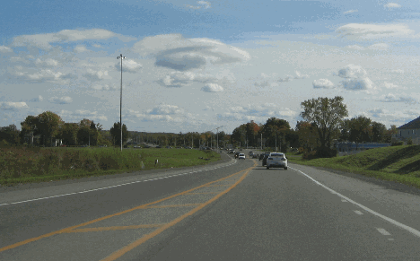
This 2006 photo shows southbound Papineau Avenue (QC 335) just south of St.-Saens Street in Laval. Note the wide right-of-way on the left reserved for the northbound lanes of A-19. Under current plans by the province, A-19 would be extended from A-440 north to A-640, with the southbound lanes of A-19 being built over the current QC 335. The A-19 extension project is currently slated for completion in 2027. (Photo by Laura Siggia Anderson.) |
||
|
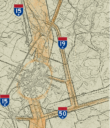
TO MIRABEL AND SAINT-JEROME: The partially completed cloverleaf interchange between A-19 and A-640 hints at a possible northern extension of A-19 toward Ste.-Anne-des-Plaines and an eastern extension of A-50. The proposed interchange between A-19 and A-50 would have been within the boundaries of an expanded Mirabel Airport. The A-19 extension, which was announced in 1969 as part of Federal and provincial plans to develop the airport, likely would have been a toll facility since it paralleled the Laurentian Autoroute (A-15), which at the time was a toll road. As Mirabel Airport never lived up to its potential, the MTQ deemed the A-19 extension north of A-640 unnecessary by the end of the 1970s. |
||
|
The late 1960s had more ambitious plans in store for A-19. In 1967, the Ministere de la Voirie du Quebec proposed an eastern bypass of Saint-Jerome extending north from A-50 (Guy Lafleur Autoroute) northwest towards A-15 (Laurentian Autoroute). Mirabel Airport was not yet an active proposal when plans were developed for the eastern Saint-Jerome bypass, but it is likely that this bypass may have been incorporated into a northern extension of A-19 had Mirabel Airport been built to its fullest extent. |
||

|
This map from the early planning stages of Mirabel Airport from the early 1970s shows the proposed northern extension of A-19, which would have served the eastern edge of the airport property. (Map credit: AirportHistory.org.) |
||
|
This 1967 map shows a preliminary plan for an eastern bypass of Saint-Jerome, along with a hypothetical A-19 designation. If Mirabel Airport had been built to its fullest extension, it is likely that a northern extension of A-19 would have continued towards Saint-Jerome. (Map credit: Ministere de la Voirie du Quebec.) |
||

|
THE "PAPINEAU DITCH": Plans for a fourth north-south autoroute crossing Montreal Island date back to the mid-1950s, when Mayor Jean Drapeau proposed a six-lane expressway first along St. Denis Street and then along St. Lawrence Street ("the Main"). In 1958, the City of Montreal began traffic studies in preparation for the city's 1960 master plan, which was to include a number of expressways crisscrossing the island. |
||
|
In 1961, the Montreal Metropolitan Committee approved the locations of a number of expressways including the Metropolitan (then under construction), Decarie, and Ville Marie (then called "East-West") autoroutes. The committee also advocated the construction of expressways along the following north-south alignments: |
||

|
This 2006 photo shows northbound Papineau Avenue just north of the Metropolitan Expressway (A-40). Although technically part of A-19, the province does not plan convert Papineau Avenue from A-40 north to Henri Bourassa Boulevard into an autoroute. Nevertheless, there are a few remnant A-19 signs along the avenue. (Photo by Laura Siggia Anderson.) |
||

|
SOURCES: "Volume of Traffic for the Proposed Expressway System, Based on Projections for the Year 1981," Ville de Montreal, Service de la Circulation (1961); "New Road Building Outlined in Detail," The Montreal Gazette (3/27/1969); "A Study of the Existing Montreal Expressway System" by Dominic Mignogna, McGill University (1969); "Bridge to South Shore Needed by 1985," The Montreal Gazette (7/23/1971); Distances Routi�res, Minist�re des Transports du Qu�bec (1983); "City of Lost Dreams" by Kristian Gravenor, The Montreal Mirror (10/26/2000); A Shared Vision for Action: Planning Framework and Government Orientations, Montreal Metropolitan Region 2001-2021, Minist�re des Affaires Municipales et de la Metropole (2001); "Deadly D�j� vu in Laval" by Catherine Solyom, Alana Coates, Marissa Larouche-Smart, and Sidhartha Banerjee, The Montreal Gazette (10/01/2006); "Maintenance Could Have Spotted Flaws" by Max Harrold, The Montreal Gazette (10/01/2006); "Green Light Given for Feasibility Study" by Jean-Maurice Duddin, Le Journal de Montreal (6/01/2007); "Overpass Inspections Lacked 'Common Sense'" by William Marsden, The Montreal Gazette (7/11/2007); "Overpass Repeatedly Given Passing Grade" by William Marsden, The Montreal Gazette (7/12/2007); "Transport Quebec, Contractor Split on Blame" by William Marsden, The Montreal Gazette (8/01/2007); "'Chain of Events Contributed to Laval Overpass Disaster," CBC News (10/18/2007); "Highway 19 To Be Extended by 2015," CBC News (6/21/2010); "PQ Puts Liberal-Approved Road Projects on Hold," CBC News (2/15/2013); "What Would Highway 19 Extension Entail?" by Roberto Rocha and Rene Bruemmer, The Montreal Gazette (12/09/2014); "Extension of Laval's Highway 19 Coming at Last, Province Says;" CBC News (4/20/2018); "Highway 19 Extension: Sighs of Relief in Laval, Worries About More Traffic in Montreal" by Rene Bruemmer, The Montreal Gazette (4/21/2018); "Transportation Takes Centre Stage" by Saul Chernos, On-Site Magazine (4/29/2024); Coalition for the Completion of Autoroute 19; Ministere des Transports du Quebec; Felix Mathieu-Begin; Stephane Dumas; Richard Dupuis; Andrew Gurudata. |
||
|
PAPINEAU EXPRESSWAY LINKS: |
||
|
PAPINEAU EXPRESSWAY CURENT CONDITIONS: |
||
|
PAPINEAU EXPRESSWAY VIDEO LINKS: |
||
|
THE EXITS OF METRO MONTREAL: |
||
|
|
||

|
Back to The Roads of Metro Montreal home page. |
||
|
Site contents © by Eastern Roads. This is not an official site run by a government agency. Recommendations provided on this site are strictly those of the author and contributors, not of any government or corporate entity. |
||