
|
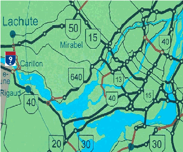
This circa 1975 map shows proposed autoroutes (displayed in red) in Greater Montreal. On the far left of the map is a red line connecting A-40 in Pointe-Fortune with A-50 in Lachute. This freeway likely would have been designated A-9, as shown on this map. (Map © by Ministère des Transports du Québec.) |
||
|
CONNECTING A-40 WITH A-50: From the 1960s through the mid-1970s, highway planners in Quebec devised plans to connect A-40 (Trans-Canada Autoroute) near Pointe-Fortune with A-50 (Outaouais Autoroute) near Lachute. The north-south autoroute was to have been near the Quebec-Ontario border just east of the Carillon hydroelectric generating station. |
||
|
Beginning at A-40 near EXIT 1 (QC 342), the proposed autoroute was to head east across the Ottawa River from Pointe-Fortune to St. André d'Argenteuil (Carillon) near QC 344. At this point, the autoroute was to veer north, roughly along the alignment of QC 327 toward A-50 near EXIT 258 in Lachute. The entire length of the proposed autoroute was to have been roughly 12 kilometers (seven miles). |
||
|
Evidence for the proposed A-9 can be found on A-40 just east of EXIT 1, where the eastbound and westbound roadways diverge for several hundred meters to accommodate ramps for a potential "directional-Y" interchange within the median. This section of A-40 was built in the mid-1960s, when long-range construction plans for A-9 may have been considered. |
||
|
The route over the Ottawa River that was to have been used by A-9 today is served by the Carillon-Pointe Fortune ferry from April through December, and by an ice bridge from January through March. |
||
|
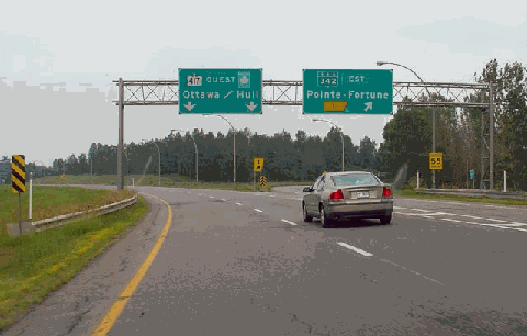
This 2005 photo shows the westbound Trans-Canada Autoroute (A-40) at EXIT 1 (QC 342) in Pointe-Fortune, just before the Quebec-Ontario border (as noted by the ON 417 shield on the overhead sign on the left). Engineers working on A-40 left a very wide median to accommodate ramps for a "directional-Y" interchange with the Pointe Fortune-Lachute Autoroute (A-9). (Photo by Scott Steeves, www.canhighways.com.) |
||

|
SOURCES: "New Road Building Outlined in Detail," The Montreal Gazette (3/27/1969); Ministère des Transports du Québec. |
||
|
POINTE FORTUNE-LACHUTE AUTOROUTE LINKS: |
||

|
Back to The Roads of Metro Montréal home page. |
||
|
Site contents © by Eastern Roads. This is not an official site run by a government agency. Recommendations provided on this site are strictly those of the author and contributors, not of any government or corporate entity. |
||