

|
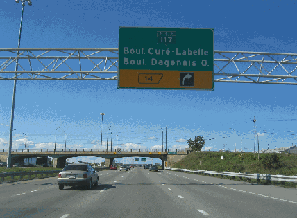
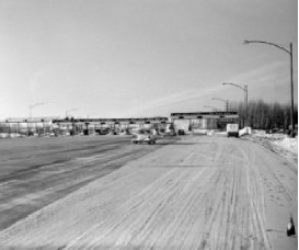
This 2006 photo shows the northbound Laurentian Autoroute (A-15) at EXIT 14 (QC 117 / Cure-Labelle Boulevard) in Laval. The concrete-arch overpass in this photo dates back to the autoroute's completion through the area in 1959. (Photo by Laura Siggia Anderson.) |
||
|
FROM MONTREAL TO THE LAURENTIANS: The Laurentian Autoroute was the first of a province-wide network of expressway envisioned by the Premier Maurice Duplessis in the 1950's. Built under the auspices of the Quebec Autoroute Authority, which financed the highway's construction through bond issuance and toll collection, the autoroute was to relieve congestion along Route 11 (now QC 117) during the summer and winter resort seasons. It also was conceived as part of the northern (Abitibi) route of the Trans-Canada Highway through northwest Quebec and northeast Ontario. |
||
|
As planned originally, the Laurentian Autoroute was to extend 47 kilometers (29 miles) from the Metropolitan Autoroute (A-40), which was under design at the time, north to QC 117 in St. Jerome. It was planned with two 51-foot-wide roadways, each accommodating three travel lanes (12 feet wide for the right and center lanes and 13 feet wide for the left lane) as well as left and right shoulders; separating the two roadways was a wide grassy median that measured 40 feet on Montreal Island and 100 feet outside Montreal. |
||
|
THE PROVINCE'S FIRST AUTOROUTE: Construction began in 1957 on the first section of the Laurentian Autoroute from Cremazie Boulevard (which eventually was rebuilt as the Metropolitan Autoroute) north to EXIT 7 in Laval; this included construction of a new bridge over Riviere des Prairies. This seven-kilometer (4.3-mile) long section was opened to traffic on November 15, 1958; it was inaugurated officially 15 days later. |
||
|
EXTENDING THE AUTOROUTE: In the first year after the Laurentian Autoroute opened, it carried as many as 35,000 vehicles per day (AADT), but as the resort area became more popular, chronic congestion was pushed further north along Route 11 past the terminus of the autoroute. It became clear that an extension was needed. |
||
|
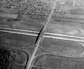
LEFT: This 1961 photo shows the Laurentian Autoroute (A-15) at EXIT 8 (QC 148 / St. Martin Boulevard) in Laval. (Photo from the Archives Nationale de Quebec / "Bilan de Siecle," University of Sherbrooke.) RIGHT: This photo from 1968 shows construction of the A-15 extension from St. Jerome north to Ste.-Agathe-des-Monts. (Photo from the Archives de Montréal and the Bibliothèque et Archives Nationales du Québec.) |
||
|
OVERPASS COLLAPSE IN LAVAL: On June 18, 2000, a new precast girder overpass being built to replace the existing Boulevard du Souvenir overpass in Laval crashed onto the Laurentian Autoroute, killing one motorist and injuring two others. One of the 16 beams of the overpass ruptured, sending all 16 beams of the overpass - each weighing about 90 tons - onto the autoroute. Since the accident occurred early on a Sunday morning, the scope of the tragedy was more limited than the 2006 collapse of the Boulevard de la Concorde overpass over the Papineau Autoroute (A-19) less than five kilometers to the east in Laval. The Laurentian Autoroute was closed for several days between EXIT 7 and EXIT 8 (QC 148 / St. Martin Boulevard) while the debris was cleared and the rest of the overpass was removed. |
||
|
A company called Beaver Ridge, which was under bankruptcy protection and operated without a construction license for four months, oversaw construction of the Boulevard du Souvenir overpass. Three weeks before the collapse, the Commission de la Sante et de la Securitie du Quebec (CSST) noted workplace irregularities, including communication problems at the site. |
||
|
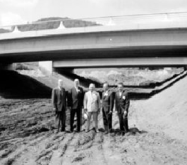
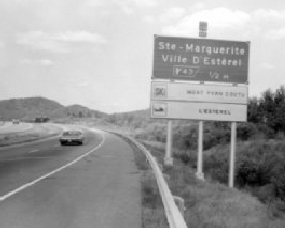
LEFT: This 1959 photo shows the Laval toll plaza near EXIT 7 (Cartier Boulevard). RIGHT: This 1974 photo shows the Laurentian Autoroute near the current EXIT 69 (former EXIT 43) / QC 370 in Ste.-Adele. Note the old-style guide sign with exit numbering based on the imperial system, which likely dates back to the opening of this section in 1963. (Photos from the Archives de Montréal and the Bibliothèque et Archives Nationales du Québec.) |
||
|
EXPANSION AND CHANGES FOR AN INTERNCHANGE: In later years, an additional travel lane was built in each direction from EXIT 3 (Henri Bourassa Boulevard) in Montreal north to EXIT 14 (QC 117 / Cure-Labelle Boulevard) in Laval. In the early 2000's, a fourth through travel lane was built from EXIT 19 (QC 344 / Grande-Cote Road) in Boisbriand north to EXIT 25 (Boulevard de la Seigneurie) in Blainville at a cost of C$56 million. |
||
|
In 2006, the Ministere des Transport du Quebec (MTQ) and the Town of Boisbriand announced plans to rebuild EXIT 20 (A-640 / North Belt Autoroute). As early as 2000, the MTQ saw the need to rebuild the interchange, through which approximately 225,000 vehicles per day (AADT) pass, as it is the primary transfer point for North Shore traffic toward Montreal to the south and the Laurentians to the north. The postponement of the A-13 extension toward Mirabel Airport has added to the congestion at the interchange. Work began on the project in mid-2007 and is comprised of the following: |
||
|
This 2006 photo shows the northbound Laurentian Autoroute (A-15) at EXIT 35 (A-50 / Outaouais Autoroute) in Mirabel. Plans from the 1960's through the early 1980's called for A-50 to extend east of this interchange toward A-40 in Berthierville. (Photo by Laura Siggia Anderson.) |
||

|
ST. JOVITE BYPASS HINTS AT NORTHERN EXTENSION: From the current end of the Laurentian Autoroute north to Labelle, Route 117 exists as a four-lane divided highway. In recent years, a freeway bypass of Route 117 was built around the resort town of St. Jovite. Exit numbers on the bypass reflect a potential extension of the Laurentian Autoroute, though there are no A-15 shields posted: |
||

|
CONTINUOUS EXIT NUMBERS FOR A-15: To avoid confusion, exit numbers should continue on the Laurentian Autoroute based on the zero kilometer-post on A-15 at the Quebec-New York border. (In this respect, A-15 is like its counterpart in New York State - Interstate 87 - because its exit numbering scheme resets within the province; it is the only autoroute to do so.) |
||
|
The new exit numbers would be posted as follows (with the old numbers in parentheses): |
||
|
NEW DESIGNATION FOR THE ST. JEROME SPUR: The St. Jerome spur from the Laurentian Autoroute should be designated Autoroute 515. The A-515 spur was part of the original autoroute mainline from 1959 until 1963. |
||

|
SOURCES: "Autoroute to Laurentians" by Charles J. Lazarus, The New York Times (10/19/1958); "An Expressway to the Laurentians" by Charles J. Lazarus, The New York Times (12/07/1958); "Laurentians' Main Street Opened" by Charles J. Lazarus, The New York Times (9/06/1959); "Easing the Way for Skiers" by Charles J. Lazarus, The New York Times (12/01/1963); "An Overpass Collapses on a Car in Laval" by Réjean Léveillé, LCN News (6/18/2000); "Laval Overpass: City Cleared of Responsibility" by Lucie Paquin, LCN News (6/20/2000); A Shared Vision for Action: Planning Framework and Government Orientations, Montreal Metropolitan Region 2001-2021, Ministère des Affaires Municipales et de la Metropole (2001); "CSST Report on Overpass Collapse," CFCF-TV (5/06/2003); "Boulevard du Souvenir Overpass: Lack of Communication Caused Accident," LCN News (5/06/2003); Bridge Engineering: Construction and Maintenance by Wai-Fah Chen and Lian Duan, CRC Press (2003); "Highway 15 and 640 Interchange To Be Revamped" by Nancy Girgis, The North Shore News (4/22/2006); "Echoes of Another Tragedy: du Souvenir Accident Claimed One Life" by Catherine Solyom, The Montreal Gazette (10/01/2006); Genivar, Inc.; Ministère des Transports du Québec; Félix Mathieu-Bégin; Richard Dupuis; Stephane Dumas. |
||

|
LAURENTIAN AUTOROUTE LINKS: |
||
|
LAURENTIAN AUTOROUTE VIDEO LINK: |
||
|
LAURENTIAN AUTOROUTE CURENT CONDITIONS: |
||
|
OFF-SITE EXIT LISTINGS: |
||
|
VIEW OR SUBMIT YOUR RATING TO RATETHEROADS.COM: |
||

|
Back to The Roads of Metro Montréal home page. |
||
|
Site contents © by Eastern Roads. This is not an official site run by a government agency. Recommendations provided on this site are strictly those of the author and contributors, not of any government or corporate entity. |
||