
|
|
||
|
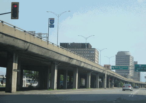
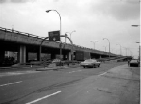
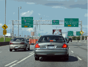
This 2013 photo shows the elevated Metropolitan Autoroute (A-40) at St. Lawrence Boulevard (Boulevard St.-Laurent). The photo was taken from eastbound Cremazie Boulevard, which is the name for the service road from the Acadie Circle east to Viau Boulevard. (Photo by Steve Anderson.) |
||
|
Length: |
||
|
49.4 kilometers (30.7 miles) |
||
|
EARLY PLANS FOR A BYPASS: Officials in Montreal made plans for a trans-island boulevard that was to bypass the city as early as 1920, and this boulevard was part of a larger plan for a Trans-Canada Highway that was to connect the major cities in the country. However, plans for the boulevard languished until 1931, when the Province of Quebec included the boulevard in its highway plans. According to figures provided by the Financial Post, the boulevard was estimated to cost C$15 million, or just over C$300,000 per kilometer for the 49 kilometers of the route. It originally was to have been financed 25% by the federal government, 25% by the province, and 50% by the municipalities on Montreal Island. Not much was done in the early years of the proposal, save for C$71,000 spent on preliminary engineering plans. |
||
|
The highway, which soon came to known as Metropolitan Boulevard, was included in 1936 as part of a broader Trans-Canada Highway; the Trans-Canada Highway itself was part of an even broader public works plan designed to lift the country out of the Great Depression. A provincial panel commissioned a report that year that recommended the highway be built as a fully controlled-access freeway. The report also recommended a mid-island route with a wide right-of-way through the West Island, using the current A-40 routing, rather than a more disruptive routing along the existing Lake Shore Boulevard and the Canadian National Railway (CN) tracks (which eventually became the routing for A-20). |
||
|
POST-WAR PLANNING: In 1951, the city of Montreal revisited plans to build a freeway along Metropolitan Boulevard. The C$100 million cost of building the freeway was too much for the city of Montreal to finance alone, so the city devised a plan to finance the cost proportionately among the 32 municipalities on Montreal Island through the Montreal Metropolitan Commission (MMC). The MMC was given the authority to impose tolls, which was designed to mitigate concerns of some municipalities, such as Verdun, that saw little direct benefit from the proposed autoroute. |
||
|
The MMC received approval to continue right-of-way acquisition in 1952, a process that continued through 1956. The right-of-way was to be 61 meters to 92 meters (200 to 300 feet) wide, enough to accommodate a six-lane freeway and service roads. |
||
|
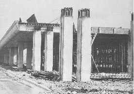
LEFT: This 1959 photo shows the elevated Metropolitan Expressway (A-40) under construction. RIGHT: This circa 1965 photo shows the completed Metropolitan Expressway looking east at the Acadie Circle. The completion of the Metropolitan Expressway encouraged industrial investment along the corridor, but in more recent years has attracted office and retail investment. (Photos by Biblioth�que et Archives Nationales du Qu�bec.) |
||
|
THE FIRST ELEVATED SECTION: Construction of the Metropolitan Expressway began in 1957 with the initial section of highway, which comprised approximately 10.5 kilometers (6.5 miles) of viaduct. That year, construction began on another freeway, the Laurentian Autoroute (A-15), which was to connect the Metropolitan Expressway with the Laurentian Mountains. This initial section of freeway from just west of the junction with the Laurentian Autoroute (EXIT 70) east to EXIT 76 (QC 125 / Pie-IX Boulevard) was completed in October 1959. This initial section was extended three kilometers (1.8 miles) west to Decarie Boulevard (EXIT 66) in 1960. The connection to the Decarie Expressway was not completed until seven years later. |
||
|
Almost immediately upon completion of this initial section, industrial parks were built along the length of the expressway, affording a variety of industries with modern manufacturing facilities and easy transportation access throughout Canada and the United States, something that was not available to industrial companies based closer to downtown Montreal. This led to explosive residential growth in the area between the Metropolitan Expressway and the Rivieres-des-Prairies. In the 20 years after the completion of the expressway, the population of the borough of Villeray-Saint-Michel-Parc-Extension had grown more than tenfold, from 6,000 to 68,000, and in the following 40 years, the population had doubled again. |
||
|
PART OF THE TRANS-CANADA HIGHWAY: In October 1960, the province reached a deal with the federal government to assume financial responsibility of the Metropolitan Expressway from the MMC. The deal had the following conditions: |
||
|
Work followed on the construction of a 16-kilometer-long (10-mile-long) section of freeway from EXIT 66 west to EXIT 50 (St. John Boulevard / Boulevard St.-Jean). This section, which includes connections to three other autoroutes (A-520 / Cote-de-Liesse Expressway, and A-13 / Chomedey Expressway), was completed in 1963. It provided the first express route from Montreal to the West Island suburbs of St.-Laurent, Pointe-Claire, and Kirkland. An extension of A-40 west to Vaudreil-Dorion--and ultimately, to the Quebec-Ontario border--was completed in 1966. Land was set aside just west of EXIT 49 (St. Mary Road / Chemin Ste.-Marie) in Kirkland for a proposed interchange with an extended Laval Expressway (A-440), which ultimately was never built. |
||
|
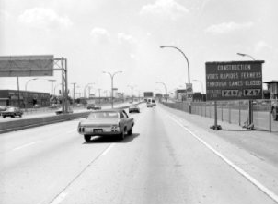
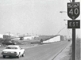
These circa 1970 photos show (upper left) a ramp to the elevated westbound A-40, (upper right) a sign alerting motorists to construction ahead on the express A-40 lanes in Montreal-Est; and (lower left) construction underway on the A-40 express lanes in Montreal-Est, while through traffic used the service roads. The Metropolitan Expressway was completed in its entirety in 1971. (Photos by Biblioth�que et Archives Nationales du Qu�bec.) |
||

|
COMPLETING THE FINAL LINK TO THE EAST: Continuing the route of the Metropolitan Expressway east of the viaduct, the province built the service roads first and left the median space open for the future construction of a six-lane freeway. The province used this "service roads first" construction strategy first years later when it built the Laval Expressway / Autoroute Jean-Noel Lavoie (A-440). |
||
|
The next section to open east of the viaduct was a two-kilometer-long (1.2-mile-long) section stretching from EXIT 76 east to EXIT 78 (Langelier Boulevard); this section was completed in 1965. Unlike the viaduct to the west, this section was built at grade level, with all but one of the grade separations built above A-40 (the only above-grade section of A-40 was built over Langelier Boulevard). At major intersections, the A-40 service roads do not intersect directly with the crossroads but rather perform as collector-distributor (C/D) roads at the same grade as the A-40 express lanes. Ramps connect to major crossroads from the A-40 service roads. |
||
|
In 1967, a five-kilometer-long (three-mile-long) section of A-40 was built from the Charles de Gaulle Bridge at the Des Prairies River west to EXIT 89 (QC 138 / Henri Bourassa Boulevard) in Point-Aux-Trembles. This section of A-40 provided a connection to the North Shore Autoroute, a toll road that eventually was extended east to Trois-Rivieres in the 1970s. |
||

|
In 1969, the Metropolitan Expressway was extended two kilometers east to EXIT 80 (A-25 / Lafontaine Expressway). This included construction of the Anjou Interchange, a complex interchange built for the intersection of A-40 and A-25. Interestingly, the A-40 service roads were extended through the interchange, but the A-25 service roads were not, forcing those motorists on a more circuitous route. |
||
|
This 2010 photo shows the eastbound Metropolitan Expressway (A-40) approaching EXIT 60 (A-13 / Chomedey Expressway). Built in the early 1960s as part of the Trans-Canada Highway, and referred locally as the "T-Can" west of A-15, this section of A-40 was rebuilt in the 2000s. (Photo by Scott Steeves, www.asphaltplanet.ca.) |
||
|
This 2010 photo shows the eastbound Metropolitan Expressway (A-40) approaching EXIT 70 (A-15 / Laurentian Autoroute). The section between the Decarie Expressway and the Laurentian Autoroute--"between the two 15s" as referred on local traffic reports--is the busiest stretch of A-40, carrying about 190,000 vehicles per day (AADT). Some of the ramps at this interchange were relocated in the early 2010s. (Photo by Scott Steeves, www.asphaltplanet.ca.) |
||
|
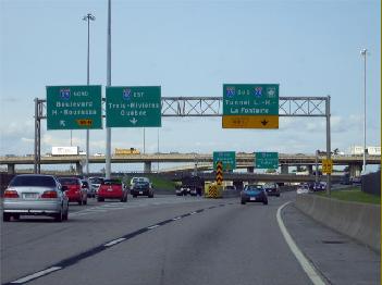
This 2010 photo shows the eastbound Metropolitan Expressway (A-40) approaching EXIT 80 (A-25 / Lafontaine Expressway). The sign for the ramp to EXIT 80N was replaced in 2011 upon the completion of the Olivier Charbonneau Bridge to Laval that year. (Photo by Scott Steeves, www.asphaltplanet.ca.) |
||

|
EARLY PLANS TO REPLACE THE MET: With the first sections of the elevated Metropolitan Expressway approaching the 30-year service mark in 1989, Montreal Mayor Jean Dore proposed replacing the elevated highway with a six-lane tunnel below ground, and a landscaped boulevard with a median park above ground. The project, which had a projected price tag of C$2 billion, was to have been similar to the "Big Dig" project designed to replace the elevated John F. Fitzgerald Expressway / Central Artery (I-93) in Boston. Dore suggested that the province pay for replacing the elevated A-40. |
||
|
INTERIM UPGRADES TO THE MET: In the meantime, the elevated section of the Metropolitan Expressway received minor upgrades in the 2000s, including the replacement of lightpoles and signs, while the Trans-Canada section of A-40 west of A-520 received a more substantial rehabilitation, including reconstructed roadways. Some modest traffic relief was provided when the A-30 bypass (South Belt Expressway / Autoroute de l'Acier) opened in 2012, and since that opened, the traffic load on the most congested section of A-40 declined to 193,000 vehicles per day (AADT) in 2018, from 204,000 vehicles in 2011. Additional relief was provided in 2013 after a two-year project to rebuild interchange ramps at EXIT 70 (A-15 / Laurentian Autoroute), which replaced the left-hand exit and entrance ramps along the eastbound A-40 with new flyover ramps that allowed motorists to exit from eastbound A-40 to northbound A-15, and enter from southbound A-15 to eastbound A-40. |
||
|
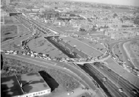
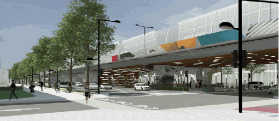
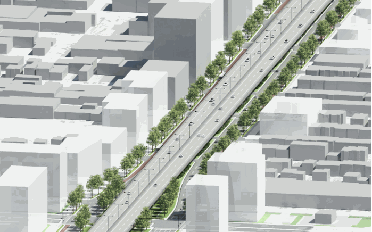
These conceptual designs from Montreal-based engineering firm SG Group International shows the viaduct replacement alternative developed under a 2011 study commissioned by the MTQ. (Exhibit credit: SM Group International, www.groupesm.com.) |
||

|
SOURCES: "Express Highways Plan Is Produced," The Montreal Gazette (1/03/1948); "Special Parley Called To Decide New Route," The Montreal Gazette (8/30/1956); "Freeway Route Approved," The Montreal Gazette (10/04/1956); "MMC May Reconsider Section in St. Laurent, Mount Royal," The Montreal Gazette (4/25/1957); "Expressway Taking Shape," The Montreal Gazette (5/15/1959); "Boulevard Across Island Cost: $122,650,855" by Myer Negru, The Montreal Gazette (6/12/1959); "Metropolitan Boulevard Ready Soon," The Montreal Gazette (8/28/1959); "Allow MMC To Submit Subway Plans: Dozois; Authority Granted To Set Metro Toll Rate" by Wilbur Arkison," The Montreal Gazette (2/03/1960); "Reconsidering the Boulevard," The Montreal Gazette (2/04/1960); "Metro Boulevard Included; Trans-Canada Pact Sets Quebec Route" by Bob Hayes, The Montreal Gazette (10/28/1960); "Superhighway To Serve Area," The Montreal Gazette (11/16/1963); "North Shore Autoroute Decision Soon," The Shawinigan Standard (2/26/1964); "Montreal-Berthierville Tollway Expected To Open June 24," The Shawinigan Standard (6/21/1967); "Police Defuse Biggest-Ever Bomb" by Eddie Collister, The Montreal Gazette (3/07/1969); "Bank Robbers Responsible for Big Bomb," The Montreal Gazette (3/08/1970); "Quebec Should Pay for Metropolitan Repairs: Margles" by Steven Morris, Town of Mount Royal-Weekly Post (2/09/1989); "End to 'Total Nightmare?' $760 Million To Solve the Metropolitan's Worst Problems" by Andre Pratte, La Presse (8/05/2000); Redevelopment of the Metropolitan Expressway in Montreal: Efficient Transportation Planning in a Dense and Compact Urban Environment by Nicolas Biussel-Roy, Transportation Association of Canada (2011); "Roadwork on the Laurentian Interchange," CFCF-TV (3/24/2012); "Dramatic Collision on Metropolitan Kills One, Closes Scene for Inspection," CBMT-TV (8/09/2016); "Tests To Determine Severity of Fire Damage on Metropolitan Expressway" by Jason Madger and Lindsay Richardson, The Montreal Gazette (8/10/2016); "Trucks Too Close in Fatal 2016 Crash" by Katherine Wilton, The Montreal Gazette (6/22/2017); "Countdown to 2022: Turning the Corner on Montreal Roadwork" by Andy Riga, The Montreal Gazette (10/16/2017); "Mega Mall Project in Town of Mount Royal To Include Traffic-Easing Measures," CBMT-TV (2/19/2018); "Montreal Is Getting a New, Bigger Ile-aux-Tortes Bridge," CBMT-TV (12/03/2018); "The Metropolitan Will Remain an Elevated Highway" by Matthieu Payen, Le Journal de Montreal (1/18/2019); Minist�re des Transports du Qu�bec; SM Group International; F�lix Mathieu-B�gin; Richard Dupuis. |
||
|
METROPOLITAN EXPRESSWAY LINKS: |
||
|
METROPOLITAN EXPRESSWAY CURRENT TRAFFIC CONDITIONS: |
||
|
METROPOLITAN EXPRESSWAY VIDEO LINKS: |
||
|
THE EXITS OF METRO MONTREAL: |
||
|
Back to The Roads of Metro Montr�al home page. |
||
|
Site contents © by Eastern Roads. This is not an official site run by a government agency. Recommendations provided on this site are strictly those of the author and contributors, not of any government or corporate entity. |
||