
|
|
||
|
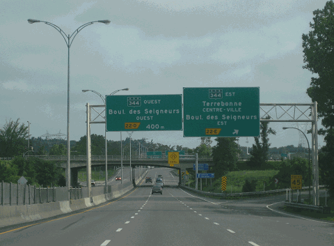
This 2013 photo shows the northbound Lanaudiere Autoroute (A-25) at Exit 22 (QC 344 / Boulevard des Seigneurs) in Terrebonne. (Photo by Steve Anderson.) |
||
|
Length: |
||
|
32.8 kilometers (20.3 miles); measured from A-440 junction in Laval to Rue Montcalm in Saint-Esprit |
||

|
FROM LAVAL TO LANUADIERE: Plans for Autoroute 25 on the North Shore date as far back as 1959. At the time, Leon Martel, the mayor of the North Shore city of Terrebonne and member of the Union Nationale, the dominant party in Quebec, mentioned unofficially to his aldermen that the new highway and bridge over Riviere des Milles-Iles would be built roughly along Reveille Street, in between QC 125 and a railroad right-of-way. The proposed alignment had the support of the Union Nationale, but not of the opposing Liberals, which favored a more westerly route via Ile Saint-Jean that would allow residential development on that island. |
||
|
With the election of Jean Lesage and the Liberal government in 1960, the nascent plans for the highway had their first revision. The newly elected Liberals proposed a "new Route 18" connecting a rebuilt Pie-IX Bridge in Montreal with Terrebonne via Laval and Ile Saint-Jean. The "new Route 18," which included a rebuilt Pie-IX Bridge and a section of Pie-IX Boulevard that was converted into a freeway, soon took on the A-25 designation. It was one of many autoroutes planned under Premier Jean Lesage's Liberal government. The Laval-to Lanuadiere section of A-25 was to intersect with two northern bypass routes, A-440 and A-640, as well as an easterly extension of A-50. A-25 was planned to extend as far north as Rawdon, and possibly as far north as Saint-Donat, at the southern end of Mont-Tremblant National Park. |
||
|
Construction of the new "Route 18" began in 1962. In 1965, a short 2.5-kilometer (1.6-mile)-long section of A-25 connecting Exit 20 (Boulevard des Mille-Iles) in Laval with Exit 23 (QC 337) in Terrebonne was opened to traffic. This section included two bridges across Rivieres des Mille-Iles (Lepage Bridge and Mathieu Bridge), between which was a short section with an interchange (Exit 21) in Ile Saint-Jean to serve residential development there. The new autoroute was re-designated A-25 in 1966. |
||
|
Work continued on two major sections of A-25 in 1968. To the south, A-25 was extended nine kilometers (five miles) southwest from Boulevard des Mille-Iles to Boulevard Pie-IX; the southernmost five kilometers (three miles) of this construction was on the A-440 right-of-way (and was temporarily signed as A-25). To the north, an 11-kilometer (seven-mile)-long section was built from Exit 23 north to Exit 34 (QC 125) in Mascouche; most of this section north of Exit 25 (A-640) was built as an undivided "super 2," with right-of-way set aside for future construction of a second carriageway. Both sections were opened in 1971. |
||
|
HOV ON THE SHOULDERS: From Exit 17 (A-440) in Laval north to Exit 21 in Ile Saint-Jean, the shoulders are converted into travel lanes for HOV use. The HOV lanes, which are in operation weekdays from 5:30am to 9:30am southbound, and from 2:00pm to 7:30pm northbound, are open to vehicles with two or more occupants, including taxis and buses, as well as motorcycles. During the hours of HOV shoulder lane operation, the speed limit on A-25 is reduced from 100 km/h to 70 km/h for all vehicles in the direction of the HOV lane usage (i.e., southbound in the morning, northbound in the afternoon and early evening). |
||

|
THAT SINKING FEELING: For a four-month period in 2017, A-25 was closed in both directions between Exit 41 (Rang ang du Ruisseau-des-Anges Sud) and Exit 44 (QC 339) in Saint-Roch-de-l'Achigan. The MTQ blamed heavy spring rains and warm temperatures for the washing out of two culverts, which ultimately led to the formation of a sinkhole seven meters (23 feet) deep and nine meters (30 feet) wide that closed both carriageways to collapse. |
||
|
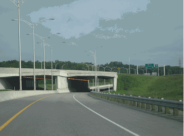
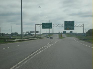
These 2013 photos show the northbound A-25 at two key interchanges. |
||
|
TOP PHOTO: Northbound A-25 (Lanaudiere Autoroute) at Exit 17 (A-440 / Jean-Noël-Lavoie Autoroute in Laval). |
||
|
BOTTOM PHOTO: Northbound A-25 (Lanaudiere Autoroute) at Exit 25 (A-640 / Autoroute des Mille-Îles) in Terrebonne. |
||
|
(Photos by Steve Anderson.) |
||

|
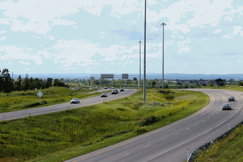
This 2011 photo shows A-25 (Lanaudiere Autoroute) looking north from Exit 41 (Rang ang du Ruisseau-des-Anges Sud) in Saint-Roch-de-l'Achigan. The MTQ had planned to extend a full four-lane freeway north to Rawdon and in the 1970s, purchased the land to do so. (Photo by Scott Steeves, www.asphaltplanet.ca.) |
||
|
TOWARD THE LOWER LAURENTIANS: As far back as the early 1960s, the Quebec government sought to extend A-25 north through the Lanaudiere region, as it foresaw increased traffic demand not only in Montreal's North Shore suburbs, but also in recreational areas, including what eventually became Mont-Tremblant National Park. The Ministere de la Voirie du Quebec (MVQ), the predecessor to the MTQ, submitted formal plans for a four-lane autoroute from Terrebonne north to Rawdon in 1970, and by 1975, the province had purchased rights-of-way all the way north to QC 125 (just north of QC 348) in Rawdon. |
||
|
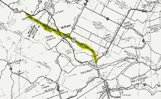
Interchanges for the 15.8-kilomter (9.8-mile)-long extension were planned at the following locations: |
||
|
This map shows the original plan for the A-25 extension to Rawdon. In its most recent incarnation, the proposal for the extension extends north only to QC 125 / QC 337 in Sainte-Julienne. (Map © by Ministere des Transports du Quebec.) |
||

|
EXTEND A-25 AS A FREEWAY TO RAWDON: A-25 should be extended north as a four-lane freeway from its present terminus at Saint-Esprit north to Rawdon. The freeway is needed to serve a fast-growing region. According to Statistics Canada, the population of Sainte-Julienne increased 65% from 1991 to 2021, while the population of Rawdon jumped 71% in the same period; during the summer months, the populations of these municipalities can double and even triple. In the not-too-distant future, Sainte-Julienne and Rawdon conceivably could become commuter suburbs of Montreal, and the present road network is not capable of meeting these future demands. |
||
|
In 2019, the MTQ and the MDDEFP came to an agreement on "Alternative 4." However, this alternate does not provide the optimal levels of service and safety on the corridor that "Alternative 3" would. The MTQ should heed the lessons it has learned during the construction of A-50 (Guy Lafleur Autoroute) and avoid the mistakes of piecemeal construction (i.e., building less than four-lane, controlled-access freeway) that have compromised safety. If budget constraints are a concern, the freeway should be built first to Sainte-Julienne, and then north to Rawdon as funds permit. |
||

|
SOURCES: Autoroute 25: du Rang du Ruisseau-des-Anges a la Route 158: Etude d'Impact sur l'Environnement, Ministere des Transports du Quebec (1993); "Le MTQ Analyse le Sol pour le Prolongement de l'Autoroute 25," L'Express de Montcalm (4/15/2011); "Pas Une 'Cenne' pour le Prolongement de l'Autoroute 25," L'Express de Montcalm (3/08/2012); "Extension of Highway 25 in Sainte-Julienne: A New Milestone Reached," Portail Constructo.com (6/15/2022); "Endangered Species Stand in the Way of the Expansion" by Vincent Larin, La Presse (10/14/2022); "Avis de Projet: Construction d'une Route Nationale dans le Prolongement de l'Autoroute 25," Ministere des Transports du Quebec (2022); Scott Steeves. |
||
|
LANAUDIERE AUTOROUTE LINKS: |
||
|
LANAUDIERE AUTOROUTE CURENT TRAFFIC CONDITIONS: |
||
|
LANAUDIERE AUTOROUTE VIDEO LINK: |
||
|
THE EXITS OF METRO MONTREAL: |
||

|
Back to The Roads of Metro Montréal home page. |
||
|
Site contents © by Eastern Roads. This is not an official site run by a government agency. Recommendations provided on this site are strictly those of the author and contributors, not of any government or corporate entity. |
||