

|
|
||
|
This 2012 photo, taken from a pedestrian overpass in Longueuil, shows the Rene Levesque Autoroute (A-20) looking southwest along the St. Lawrence River shoreline. This section was rehabilitated and received new continuous exit numbers matching those of the rest of A-20 in the early 2010s. (Photo by Scott Steeves, www.asphaltplanet.ca.) |
||
|
Length: |
||
|
72.2 kilometers (44.8 miles); total length |
||
|
Constructed: |
||
|
1963-1967 |
||
|
Scope note: According to the Commission de Toponymie du Quebec, the Rene-Levesque Autoroute officially refers only to a 25-kilometre (16-mile) section of freeway extending from Autoroute 15 EXIT 42 (A-930 / QC-132) in Candiac north to Autoroute 20 EXIT 89 (A-25 / Louis-Hippolyte-Lafontaine Tunnel) in Longueuil. |
||
|
Autoroute 20 from EXIT 75 (A-10 / A-15 / Champlain Bridge) in Brossard to EXIT 89 (A-25 / Lafontaine Tunnel) in Longueuil; and QC Route 132 from the A-20 / A-25 interchange in Longueuil to the Montbrun Street traffic signal in Boucherville. |
||

|
A MUCH-NEEDED SOUTH SHORE LINK: In 1955, officials from the National Harbours Board, along with various provincial and local officials, met to discuss growing congestion on the Jacques Cartier, Victoria, and Mercier Bridges between Montreal and the South Shore. The board held these discussions in the context of the development of a broader expressway network around Montreal. These discussions eventually yielded the announcement of a new span - the Nuns' Island Bridge, later known as the Champlain Bridge - from Montreal to the South Shore. |
||
|
With specific regard to the South Shore, planners soon began to create plans for a 13-mile (21-kilometer), six-lane expressway link with service roads to distribute traffic between the Champlain, Victoria, and Jacques Cartier Bridge, as well as a new crossing then under development (the Lafontaine Tunnel), and various South Shore communities. Almost immediately, however, the proposed South Shore expressway from Candiac north to Boucherville - which was to be a relocated Route 3 - ran into opposition from some South Shore communities that feared the loss of waterfront land. Instead, some opposition leaders advocated a more inland bypass. |
||
|
Gaining more traction was a proposal to widen and modernize the existing Route 9 - then a two-lane rural road and an extension of US 9 from New York State - into a four-lane freeway. Local and provincial leaders saw the need to provide a freeway connection to I-87 in New York State, as the state's Department of Public Works approved its construction in 1957. A more modern Route 9 freeway, in conjunction with I-87, would for the first time provide a direct freeway link between Montreal and New York City, some 590 kilometers (365 miles) to the south. |
||

|
However, with the exception of the Trans-Canada Highway--whose construction was funded at a 90% federal share--the Canadian provinces generally received federal reimbursement for only about 50% of freeway construction costs. In contrast, the US Interstate Highway program provided states with a 90% federal share. This difference in funding likely contributed to a slower pace of expressway development in Canada, and in Qu�bec in particular, where early freeway construction often relied on toll facilities such as the Eastern Townships Autoroute (A-10) and the Laurentian Autoroute (A-15). |
||

|
This 2006 photo shows the Rene Levesque Autoroute at EXIT 53 (A-10 / A-15 / A-20 /Champlain Bridge approach) in Brossard. View is looking north. At this point, the A-15 designation and exit numbering scheme exit the Rene Levesque Autoroute, and the A-20 designation and exit numbering scheme continue straight ahead. Until the early 1970s, the section autoroute from Candiac north to Boucherville was designated as Quebec Route 3. (Photo by Laura Siggia-Anderson.) |
||
|
IT'S ALL ABOUT EXPO: The pace of expressway construction in Quebec changed dramatically in the early 1960s. Following the award of Expo 67 to Montreal in 1962 -- after the withdrawal of the Soviet Union from hosting the 1967 exposition -- provincial and municipal authorities faced a fixed international deadline that required the rapid expansion of the region's transportation network. As a result, several autoroute projects on both the Island of Montreal and the South Shore were advanced more rapidly than might otherwise have been possible. |
||
|
In August 1962, three months before Montreal formally received the World's Fair bid, the mayors of several South Shore communities reached an agreement for the construction of a new Route 3 expressway along the St. Lawrence waterfront. Much of the waterfront land on the proposed route was owned by the Federal government, so little land would need to be acquired for the expressway right-of-way. Most of the mayors agreed that the waterfront route would not only help alleviate traffic on Taschereau Boulevard (current QC 134), but also serve as a catalyst for their own waterfront plans, such as parks. |
||
|
The proposed Route 3 expressway was conceived as part of a longer-term relocation of existing Route 3 along the St. Lawrence waterfront as far northeast as Sorel-Tracy. Meanwhile, the inland route proposed by some citizen groups, however, was not completely abandoned, as that eastern bypass eventually formed the basis for the province to develop plans for a new Route 3A expressway, which eventually became A-30. |
||
|
Meanwhile, the Quebec government moved the modernization of Route 9 from Candiac south to the Canada-US border in Lacolle to a priority project in June 1963. Anticipating an influx of visitors from New York and other states to Expo 67 in less than four years, and with construction of I-87 (Adirondack Northway) well underway in upstate New York (it was already completed from Albany north to Saratoga Springs), Bernard Pinard, the head of the Ministere de la Voirie du Quebec (MVQ), called the modernization of Routes 3 and 9 between the border and the South Shore a top priority for the province. |
||
|
CONNECTING MONTREAL TO THE BORDER: Improvements to Route 3 occurred alongside the reconstruction of Route 9 between La Prairie and the United States border, indicating that both the east-west and north-south approaches to Montreal were being modernized during the same period. Specifically, Routes 3 and 9 were part of a coordinated buildout as follows: |
||

|
BACK IN TIME: This 1970 photo shows the Route 3 expressway co-signed with Autoroute 20. This photo, which shows a view looking southwest towards the old Champlain Bridge, was taken at the current EXIT 78E (QC 112 East). (Photo from the Ministere de la Voirie du Quebec, 1969-1970 annual report.) |
||

|
AND LATER: This 2013 photo shows the Rene Levesque Autoroute (A-20) approaching EXIT 89 (A-20 / A-25) in Longueuil. View is looking northeast. Note the transition in the exit numbering scheme to that of A-20. Until 2012, this stretch of A-20 along the St. Lawrence River used an exit numbering scheme for the proposed, but never completed A-430.(Photo by Steve Anderson.) |
||
|
NEW DESIGNATIONS: The completion of the Route 3-Route 9 improvements in late 1966 also marked the start of new designations for Quebec's autoroute system, which were based on a grid similar to that of the Interstate highway system in the United States. |
||
|
|
||
|
|
||
|
To ease motorists onto the new designations, the existing Routes 3 and 9 designations appeared on the expressway alongside the new A-15 and A-20 signs until 1973, when the province provided new designations for its non-autoroute principal routes. |
||
|
The Longueuil-to-Boucherville segment received its own new designation in 1973 when Route 3 signs were replaced with QC 132 signs. The QC 132 designation continued south along the corridor all the way to Candiac - it was co-signed along the A-20 and A-15 sections - before departing west towards Chateauguay. The new QC 132 designation was part of a province-wide initiative to re-designate primary non-autoroute highways in a grid system. The Longueuil-to-Boucherville segment also was to have been part of A-430 - a bypass of A-30 - until that project was canceled in 1981. |
||

|
This 2013 photo shows the Rene Levesque Autoroute (QC 132) at EXIT 136 (Marie Victorin Boulevard) in Boucherville. View is looking southwest. The Route 132 stub of this autoroute was planned as part of a more ambitious A-430, which was canceled in 1981. Until 2024, this stretch of QC 132 used an exit numbering scheme for the proposed, but never completed A-430. (Photo by Steve Anderson.) |
||
|
CHANGES FOR THE A-30 INTERCHANGE: From 1993 to 1996, the Ministere des Transports du Quebec (MTQ) made significant improvements to EXITS 40-42 (QC 132 / A-30 / A-930) in Candiac. When A-15 was built through Candiac in the 1960s, the province built a partial cloverleaf interchange to serve QC 132 west towards Sainte-Catherine and Chateauguay, as well as a northbound collector-distributor (C/D) road to serve movements between QC 132 and northbound A-15. It had graded a southbound C/D roads and several other ramps to serve movements for the yet-to-be-built A-30. |
||
|
The mid-1990s extension of A-30 (De l'Acier Autoroute) from A-10 in Brossard southwest towards A-15 in Candiac brought construction of the cloverleaf interchange's missing movements, as well as the southbound A-15 C/D road, finally marking completion of the full cloverleaf interchange nearly three decades after the partial interchange was first built. |
||
|
In 2019, the MTQ implemented a bus-only shoulder lane along the eastbound section of the QC 132 of the autoroute from EXIT 138 (De Montarville Boulevard) east to the signalized intersection of De Montbrun Street. The shoulder lane is open exclusively to buses from 3:30pm to 6:30pm weekdays. |
||
|
NAME CHANGE: In 2013, the Commission de Toponymie du Quebec named a 25-kilometer (16-mile) stretch of Autoroutes 15 and 20 the "Autoroute Rene-Levesque" in honor of the founder of Parti Quebecois and former Quebec Premier, who served in that office from 1976 to 1985. This section of autoroute crosses the Taillon electoral district, which Levesque represented. |
||
|
WE'VE GOT YOUR (EXIT) NUMBER: In 2012, the MTQ changed the exit numbers along the A-20 section of the Rene Levesque Autoroute to aid motorists by providing a more consistent exit numbering scheme along A-20. Prior to 2012, the province-wide A-20 exit numbering scheme - which begins at the Ontario-Quebec border - was interrupted along this stretch, as it had used the exit numbering scheme for the once proposed A-430 beginning at the Champlain Bridge approach in Brossard. |
||
|
Similarly, in 2024, the MTQ changed the exit numbers along the QC 132 section of the autoroute, through the exit numbers begin at EXIT 136 to reflect the distance in kilometers from the beginning of QC 132 at the Canada-US border in Dundee (near Saint-Anicet). Prior to 2024, this stretch had continued the exit numbering scheme for the once proposed A-430. |
||

|
BEFORE AND AFTER� |
||

|
MIDDLE: This 2006 photo shows the northbound A-15 (Rene Levesque Autoroute) at the Canadian Pacific railroad underpass in Candiac. The underpass likely predated the modernization of Route 9 / A-15 in the 1960s, as characterized by the lack of a shoulder and somewhat steep grade into the underpass. Photo by Laura Siggia-Anderson.) |
||

|
BOTTOM: This 2013 photo shows the southbound A-15 (Rene Levesque Autoroute) at the Canadian Pacific railroad underpass in Candiac. The railroad underpass was completely rebuilt to accommodate extended C/D roads while improving safety on the mainline A-15. This improvement was completed in 2012. (Photo by Steve Anderson.) |
||

|
WHERE DOES A-430 FIT IN THIS DISCUSSION? Planning for what would eventually become Autoroute 430 began in 1964 as part of the Route 3 expressway plan. As originally planned, Route 3 was to be the "waterfront" route from Candiac to Varennes, while a bypass route, which was first known as Route 3A, was to be a more inland, circumferential expressway route between Candiac and Varennes. |
||
|
By 1966, the inland route between Candiac and Varennes was re-designated as Autoroute 30. In 1971, the province re-designated the waterfront route as Autoroute 430, effectively creating a bypass of Autoroute 30. However, from Candiac north to Brossard, A-430 was to be dually signed with A-15, and from Brossard north to the current A-20 / A-25 junction in Longueuil, the A-430 designation was to be a standalone one, pending the relocation of the A-20 designation to the Ville Marie Expressway in Montreal. As the Ville Marie Expressway was never completed between the Jacques Cartier Bridge (QC 134) and the Lafontaine Tunnel (A-25), the A-20 designation stayed along the South Shore, where it remains to this day. |
||
|
Northeast of the A-20 / A-25 junction, the A-430 designation was to continue along the current QC 132 expressway to Boucherville, though from De Montbrun Street in Boucherville to QC 229 in Varennes, the existing Route 132 would have been upgraded to freeway standards, and from QC 229 northeast to A-30 in the vicinity of the current EXIT 95 (Butte-aux-Renards Road), A-430 would have been built on a new right-of-way. |
||

|
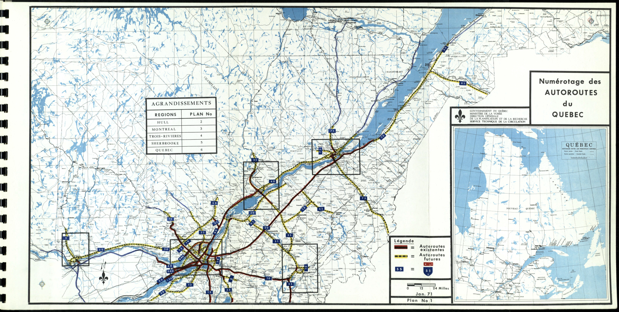
This map from the MTQ's 1971-72 annual report depicts the A-430 designation applied to the Rene Levesque Autoroute along the South Shore of the St. Lawrence River, assuming the completion of the Ville Marie Expressway (shown here as the "Autoroute Est-Ouest"), which was to carry the A-20 designation. As this expressway was never fully completed, the A-20 designation stayed on the South Shore. (Map © 1972 Ministere de la Voirie du Quebec.) |
||

|
This 1975 MTQ map depicts A-430 as an autoroute along the entire length of QC 132 between Longueuil and Varennes. QC 132 was built as a surface-level arterial -- not an autoroute -- northeast of Boucherville, while the A-430 connection to A-30 was not built at all. (Map © 1975 Ministere des Transports du Quebec.) |
||

|
CONGESTION RELIEF FOR CANDIAC: The MTQ should widen A-15 to six through lanes - three in each direction - for a three-kilometer (two-mile)-long stretch from EXITS 40-42 (A-30 / A-930 / QC 132) north to EXIT 45 (QC 134 / Taschereau Boulevard). The daily traffic count along this stretch is about 60,000 (AADT), and the mix of local and long-distance traffic can make for challenging travel conditions. Moreover, increased development along the South Shore may warrant a long-term reconstruction of this segment. |
||

|
INCREASE SPEED LIMIT FROM A-30 SOUTH TO THE BORDER: Along a 37-kilometer (23-mile)-long stretch of A-15 from just south of A-30 in Candiac to just north of the Canada-US border in Lacolle, the MTQ should pilot a test of an increased 110 km/h (68 MPH) speed limit and a 70 km/h (43 MPH) minimum, which would be consistent with speed limits in adjacent provinces and states. |
||

|
SOURCES: "North-South Link Necessary To Connect Three Expressways" by Herb Lampert, The Montreal Gazette (4/03/1957); "Northway Route Mapped Through Adirondacks," The New York Times (4/21/1957); "Bridge Link," Ottawa Citizen (2/20/1962); "Mayors from South Shore Approve Route for Waterfront Expressway," The Montreal Gazette (8/09/1962); "City Expressway System Proposed" by Gordon Pape, The Montreal Gazette (6/01/1963); "Widening of Route 9 To US Border Among Eight Major Projects This Year," The Montreal Gazette (6/13/1963); "Montreal Spawns Roads, Bridges, Tunnels" by Bob Hayes, The Montreal Gazette (12/02/1964); "Vingt et une Soumissions Publique d'Ici Mars '65," L'Echo de Lotbini�re (12/25/1964); "Candiac-Boucherville Link Near Completion," The Montreal Gazette (10/20/1965); "Expressway Opens Today," The Montreal Gazette (12/03/1965); "Ouverture de la Nouvelle Route a Six Voies Entre Candiac et Jacques-Cartier," Le Devoir (12/03/1965); "Ouventure d'Une Nouvelle Autoroute," La Presse (12/03/1965); "Opening Today for 92 Miles of Autoroute," The Montreal Gazette (12/17/1966); "Ville de Boucherville: La Ville Vous Informe (Assemblee Reguliere: Ordre du Jour)," La Seigneurie (9/16/1981); "Project d'Autoroute Abandonee," La Seigneurie (9/16/1981); Prolongement de l'Autoroute 30 Entre les Autoroutes 10 et 15, Ministere des Transports du Quebec (1993); Extension of Autoroute 30, Canadian Environmental Assessment Agency (1995); "Saga of Highway 30 Takes Us Back to 1966," The Montreal Gazette (3/07/2003); "Autoroute 30 Completion "a Contentious Issue" in Kahnawake" by Dan Rosenburg, The Eastern Door (3/14/2003); "This Time, It's for Real," The Montreal Gazette (11/06/2006); "Highway 30 Timeline," The Montreal Gazette (11/06/2006); "Press Release: Une Portion de la Route 132 Nommee Autoroute Ren�-L�vesque," Commission de Toponymie du Quebec (12/05/2013); "On Time, Under Budget, Not Without Controversy" by Leigh Hornbeck, The Albany Times-Union (8/21/2018); Ministere des Transports du Quebec; Richard Dupuis; Paul Lansing. |
||
|
RENE LEVESQUE AUTOROUTE LINKS: |
||
|
RENE LEVESQUE AUTOROUTE CURENT TRAFFIC CONDITIONS: |
||
|
RENE LEVESQUE AUTOROUTE VIDEO LINKS: |
||
|
THE EXITS OF METRO MONTREAL: |
||

|
|
||

|
Back to The Roads of Metro Montr�al home page. |
||
|
Site contents © by Eastern Roads. This is not an official site run by a government agency. Recommendations provided on this site are strictly those of the author and contributors, not of any government or corporate entity. |
||