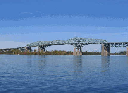
This 2006 photo shows the Champlain Bridge (A-10, A-15, and A-20) across the main channel of the St. Lawrence River from the Brossard shoreline. (Photo by Steve Anderson.)
THE FOURTH BRIDGE TO THE SOUTH SHORE, BUILT WITH THE SEAWAY IN MIND: In 1955, officials from the National Harbours Board, as well as various provincial and city officials, met to discuss growing congestion on the Jacques Cartier, Victoria, and Mercier Bridges between Montreal and the South Shore. These discussions were held within the context of a proposed expressway network around Greater Montreal, as well as by the necessity of a new fixed span under which ships on the then-under construction St. Lawrence Seaway could pass. At that time, none of the existing Montreal bridges across the St. Lawrence had enough clearance to accommodate ocean-bound vessels.
During the summer of that year, the National Harbours Board set up a technical committee to decide upon an appropriate location. On August 17, 1955, Federal Transport Minister George Marler announced plans for a toll bridge connecting Brossard on the South Shore with Nun's Island (Ile des Soeurs).
The "Nuns' Island Bridge" - as it was called initially - was first planned as a four-lane span with provisions for two additional lanes to be added later. However, officials decided to build a six-lane bridge after a subsequent study found there would be significant traffic from newly suburbanized South Shore communities. Connections were to be built from Nuns' Island to downtown Montreal and the West Island. The bridge also was to connect directly to local streets on Nuns' Island, where a private group had purchased the island from the Congregation of Notre Island several years earlier and planned a C$40 million residential and commercial development.
During the summer of that year, the National Harbours Board set up a technical committee to decide upon an appropriate location. On August 17, 1955, Federal Transport Minister George Marler announced plans for a toll bridge connecting Brossard on the South Shore with Nun's Island (Ile des Soeurs).
The "Nuns' Island Bridge" - as it was called initially - was first planned as a four-lane span with provisions for two additional lanes to be added later. However, officials decided to build a six-lane bridge after a subsequent study found there would be significant traffic from newly suburbanized South Shore communities.
Connections were to be built from Nuns' Island to downtown Montreal and the West Island. The bridge also was to connect directly to local streets on Nuns' Island, where a private group had purchased the island from the Congregation of Notre Island several years earlier and planned a C$40 million residential and commercial development.
Preliminary work got underway in 1956 when engineers made borings into the St. Lawrence River. The National Harbours Board also began right-of-way acquisition for bridge approaches that year.
In 1957, the National Harbours Board selected Philip Louis Pratley as the chief engineer of the project. A designer of bridges in Canada and the United States for more than half a century, Pratley worked on the Jacques Cartier Bridge just upriver from the Nuns' Island site. However, Pratley died one year after being awarded the project; son H.H. Pratley took over upon his elder's death. At this time, the bridge received a new name: the Champlain Bridge.
SUPPORTING THE BRIDGE: Nearly all of the more than 50 concrete piers for the bridge were built in the St. Lawrence River. The in-water caissons rest on a bed of shale averaging 12 meters (39 feet) below the high water mark and as deep as 26 meters (85 feet) beneath the river. The main piers were given a circular design to resist the heavy winter ice flows of the St. Lawrence, while the approach piers were given a more conventional T-shaped design. It took an average 28 days to set a pier into the river, with the most difficult ones taking as many as 49 days.
The National Harbours Board awarded the first construction contract of the project on July 25, 1957; it was for the construction of the four concrete piers supporting the steel superstructure. Engineers deemed it necessary to build these piers before the end of the 1957 construction season - when the St. Lawrence Seaway channel (which also was being built at the time) was scheduled to be flooded - so this work was expedited.
The following year, the National Harbours Board awarded the contract to build the remaining 44 piers. Separate contracts awarded in 1958 were for the construction of temporary dams (in preparation for the pier work) and fill work on Nuns' Island.
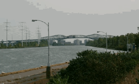
This 2003 photo shows the Champlain Bridge looking south from the St. Lawrence Seaway pedestrian / bicycle path. The bridge is undergoing the final year of a three-year redecking project in this photo. (Photo by Nicolas Janberg, www.structurae.de.)
BUILDING THE APPROACH SPANS: On June 25, 1959, the MKD Partnership (comprised of McNamara Quebec, Key Construction, and Deschamps and Belanger) won the C$8.3 million to build the 50 approach spans and roadways on either side of the superstructure. The western approach is comprised of 40 spans each measuring 53.7 meters (176 feet, four inches) long. The eastern approach has ten spans of varying length: four measuring 53.7 meters long, two measuring 51.4 meters (168 feet, eight inches), three measuring 52.5 meters (172 feet, four inches) long, and one measuring 52.7 meters (172 feet, ten inches) long. The approaches are sloped 0.85% on the Montreal side and 3% on the Brossard side.
Engineers used pre-stressed concrete girders - which included tension cables to provide additional strength - for the approach spans, marking the first time such girders were used on a major structure in Canada. A temporary manufacturing facility on Nuns' Island churned out 476 pre-stressed girders; the plant made an average of three girders per day. Two traveling cranes transported the girders, while a larger 113-meter (370-foot) high crane installed the girders into place.
THE SUPERSTRUCTURE: The Dominion Bridge Company won the C$5.9 million contract to build the steel superstructure and roadway on October 1, 1959. Construction of the superstructure was comprised of a 215.5-meter (706-foot, nine-inch)-long main cantilever span, two 117.5-meter (385 foot, six-inch)-long side cantilever spans, and four steel-truss deck spans measuring 78 meters (257 feet) long. The superstructure was comprised of 11,000 tons of structural steel.
As the St. Lawrence Seaway already had opened by the time work began on the superstructure, workers were prohibited from installing falsework and using floating cranes in the shipping channel. Work proceeded cantilever-style from the two center piers until the two sections met at mid-span on September 21, 1961, marking the laying of the last piece of steelwork.
BUILT FOR THE AUTOROUTE AGE: When the six-lane Champlain Bridge opened to traffic on June 29, 1962, it connected only to local streets. An extension of the Decarie Autoroute (A-15 and A-20), which opened in 1963 to provide access to Atwater Avenue and La Verendrye Boulevard, was the first autoroute approach to the bridge. Traffic on the Champlain Bridge increased dramatically upon the completion of the Eastern Townships Autoroute (A-10) in 1964, the Monteregie Autoroute (A-15) in 1966, and the Bonaventure Autoroute (A-10) in 1967.
A 25-cent toll was charged to finance the C$35 million cost of the Champlain Bridge. The toll was collected until 1990, when the Jacques Cartier and Champlain Bridges Incorporated (JCCBI), which took over jurisdiction of the bridge a dozen years earlier, removed the toll plaza.
MAINTAINING THE BRIDGE: For three and one-half years in the early 1990's, the JCCBI oversaw the C$40 million replacement of the existing steel deck with an orthotropic steel deck. The new orthotropic deck - the first of its type in Quebec - is lighter than the deck it replaced. However, it promises double the lifespan of a traditional steel deck (60 years versus 30 years), as well as greater load capacity and more durability than a traditional deck. Most of the deck panels were replaced at night, but engineers kept at least two traffic lanes in operation during the overnight construction period, and all six lanes open during peak travel periods.
According to the JCCBI and Transport Quebec, the Champlain Bridge carries approximately 135,000 vehicles per day (AADT) as part of A-10, A-15, and A-20, making the bridge the busiest in Canada.
Since 1982, the left lanes in each direction have been reserved for buses during weekday morning and afternoon rush hours. These lanes are estimated to carry 30,000 passengers per day.
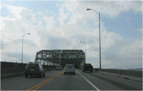
This 2006 photo shows the westbound lanes of the Champlain Bridge (A-10, A-15, and A-20). The double yellow line is used to separate bus-only traffic flows during peak travel periods. (Photo by Laura Siggia Anderson.)
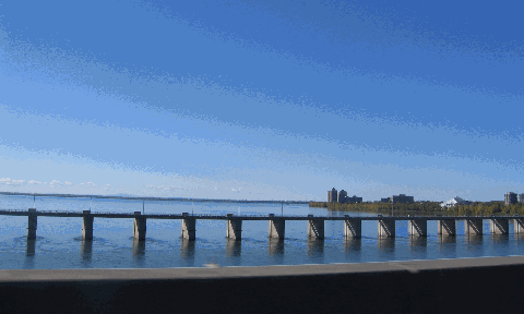
THE ICE CONTROL STRUCTURE (ESTACADE): The construction and expansion of Ile Notre- Dame and Ile Ste.-Helene for Expo '67 reduced the width of the St. Lawrence River. This not only increased the chances of ice jams and erosion, but also threatened the structural integrity of bridge piers in the river. To remedy this problem, the National Harbours Board issued a construction contract for the C$18 million Champlain Bridge Ice Control Structure, which also is referred as the "estacade."
Built about 300 meters (1,000 feet) south of the existing Champlain Bridge, the ice control structure is a long, 73-span viaduct stretching 2,043 meters (6,700 feet) from Nuns' Island to the western barrier of the St. Lawrence Seaway. The three main spans over the deep water channel - each measuring 53 meters (175 feet) long - were equipped with booms that floated with the current. The booms were detached in early spring to allow an ice evacuation channel to form. The remaining 70 spans - each measuring 27 meters (88 feet) long - were equipped with booms that held back the ice; they moved up and down in heated grooves in the piers. All 73 spans were of pre-stressed girder design and supported by concrete piers measuring as much as 8.5 meters (28 feet) beneath the St. Lawrence.
The estacade was completed in 1965, and transferred to Fisheries and Oceans Canada the following year. It was transferred back to the JCCBI in 1999. Although it is no longer in operation (ice breakers now carry out the job of clearing the river), the ice control structure has an 8.5-meter-wide roadway that accommodates pedestrian and bicycle traffic.
NEW LIFE FOR THE ESTACADE: In 2000, the Federal government and city officials announced plans for a C$640 million conversion of the ice control structure for use by light rail transit (LRT) as well as pedestrians and cyclists. The bridge would be an integral part of a proposed 23-kilometer (14-mile) LRT network connecting Montreal with South Shore communities. The conversion proposal has not advanced beyond the planning stage.
This 2006 photo shows the ice control structure (or "estacade") built alongside the Champlain Bridge. The parallel span is planned for light rail transit (LRT) use between Montreal and South Shore communities. (Photo by Laura Siggia Anderson.)
Type of bridge: Construction started: Opened to traffic: Length of main cantilever span: Length of each side cantilever span: Length of steel superstructure: Length, abutment to abutment: Width of roadway: Number of traffic lanes: Clearance at center above mean high water: Deepest foundation below mean high water: Foundation type: Cost of original structure:
SOURCES: "Seaway Breeds Montreal Jams," The New York Times (1/29/1956); "Philip Pratley, 73, A Bridge Designer," The New York Times (8/02/1958); "Boom in Highways Buoys Montreal As Suburbs Grow" by Charles J. Lazarus, The New York Times (1/14/1959); "Montreal Bridge" by Charles J. Lazarus, The New York Times (7/08/1962); "A Study of the Existing Montreal Expressway System" by Dominic Mignogna, McGill University (1969); "Transport Management Plan, Greater Montreal Area," Transport Quebec (2000); "Montreal Light Rail Proposed to Complement Expanding Metro" by C.J. Wansbeek, Tramsways and Urban Transit / Light Rail Transit Association (July 2001); Federal Bridge Corporation; Jacques Cartier and Champlain Bridges Incorporated; Transport Canada.
A-10, A-15, and A-20 shields from Wikipedia. Lightpost photos by Laura Siggia Anderson.