

|
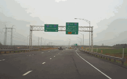
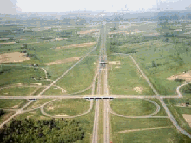
This 2002 photo shows the eastbound Eastern Townships Autoroute (A-10) at EXIT 22 (A-35 / Vallee des Forts Autoroute). The interchange borders the towns of Carignan and Chambly. (Photo by Douglas Kerr, www.gribblenation.com.) |
||
|
A ROUTE FOR THE EASTERN TOWNSHIPS: The success of the Laurentian Autoroute (A-15) in the late 1950's, which was built under the government of Premier Maurice Duplessis, prompted officials to develop a toll road to serve resort areas in the Eastern Townships. Even with the dramatic shift in government with the arrival of Premier Jean Lesage and his Liberal Party in 1960, the need for an expressway connecting Montreal with Sherbrooke was seen as no less important. |
||
|
That year, the Quebec Autoroutes Authority - which built the Laurentian Autoroute as a bond-financed, toll-supported turnpike - announced plans for the Eastern Townships Autoroute (Autoroute des Cantons de l'Est). The proposed autoroute was to bypass old Route 1 (now QC 112), which gained notoriety as one of the most congested and dangerous roads in the province. |
||
|
|
||
|
The Eastern Townships Autoroute was completed on December 22, 1964, about six months ahead of schedule and in time for the 1965 ski season. This autoroute was designated A-10 in 1966. Tolls were collected on the autoroute until 1985; the toll plazas subsequently were dismantled, leaving remnants in the form of extended loop ramps at EXIT 37 and EXIT 90, as well as the rotary configuration of the ramps below EXIT 115. |
||
|
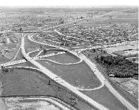
These 1970 photos show the Eastern Townships Autoroute (A-10) looking east at EXIT 37 (QC 227) in Ste.-Marie-de-Monnoir (left photo) and looking west at EXIT 90 (QC 243) in Shefford. (Photos from the Archives de Montréal and the Bibliothèque et Archives Nationales du Québec.) |
||

|
UNTANGLING THE TASCHEREAU INTERCHANGE: The MTQ began work in 2002 to rebuild EXIT 8 (QC 134 / Taschereau Boulevard) and EXIT 9 in Brossard. When it was designed in the early 1960's, the "Taschereau interchange" was ahead of its time with its wide center median and mix of right-hand and left-hand ramps, but ultimately proved woefully adequate - and unsafe - for the 100,000 motorists who traverse the interchange on A-10 each day. |
||
|
The Taschereau interchange project was comprised of the following improvements, which was being carried out over five phases: |
||
|
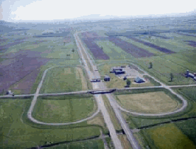
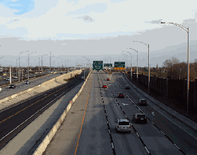
LEFT: This 1967 photo shows the Eastern Townships Autoroute (A-10) looking east at the "Taschereau interchange." Note the left-hand exit ramps and light traffic. Today, about 100,000 vehicles per day pass through this interchange on A-10. (Photo by Ministere des Transports du Quebec.) RIGHT: This 2008 photo shows EXIT 8 (QC 134 / Taschereau Boulevard) following the completion of Taschereau interchange and A-10 bus lane project. (Photo by Scott Steeves, www.canhighways.com.) |
||

|
A LINK EAST OF SHERBROOKE: As conceived in the early 1970's, the "Eastern Townships Autoroute Extension" may have been planned at least as far east as A-73 near St.-Georges. During the early 1980's, A-10 was extended east along a newly built section of A-55 around Sherbrooke, and in the late 1980's and early 1990's, a stub of A-10 east of A-55 was built to QC 112 in Ascot Corner, just east of Sherbrooke. Nevertheless, the future of A-10 remained in doubt. |
||
|
More recent plans developed by Maine and Quebec transportation officials in 1999 proposed an A-10 extension east to Woburn; a new east-west highway (unofficially dubbed I-92 by many members of the misc.transport.road newsgroup) was planned along ME 27 and US 2 toward I-95 in Newport, Maine. However, the 1999 study found that the costs of such a highway did not appear justified at the time. |
||

|
No new construction along the A-10 corridor was completed since the opening of the final extension to Ascot Corner in late 1992. On September 29, 2006, the MTQ re-designated the 11-kilometer (seven-mile)-long A-10 stub from A-55 in Sherbrooke east to QC 112 in Ascot Corner as the new A-610. A-610 was renamed in honor of Sherbrooke-area television personality Louis Bilodeau in 2008. |
||

|
SIX LANES EAST TO A-35: In conjunction with the A-35 "missing link" project scheduled for completion by 2015, A-10 should be widened from EXIT 11 (A-30) east to EXIT 22 (A-35). A rebuilt EXIT 22 complete with two-lane, high-speed ramps (A-10 eastbound to A-35 southbound, and A-35 northbound to A-10 westbound) also should be built. |
||
|
RESTORE A-10 EAST TO ASCOT CORNER: The A-10 designation should be restore to the short section from A-55 east to QC 112 in Ascot Corner for a future eastern extension toward Maine's proposed East-West Highway and the Maritimes. |
||

|
SOURCES: "Superhighway to Montreal Opening Tuesday" by Charles J. Lazarus, The New York Times (12/20/1964); "A Summary of the Findings of Studies Regarding a Maine East-West Highway," Maine Department of Transportation and Maine State Planning Office (1999); "Vers un Plan de Transport pour le Centre-du-Quebec," Ministère des Transports du Québec (1999); "How Tolls Could Reduce Traffic on Our Highways" by Fred Langan, Newsworld Business News (6/12/2000); A Shared Vision for Action: Planning Framework and Government Orientations, Montreal Metropolitan Region 2001-2021, Ministère des Affaires Municipales et de la Metropole (2001); "Implementation of a Light Rail Transit (LRT) System in the Highway 10 / Downtown Montreal Corridor," Agence Metropolitaine de Transport (2007); "Autoroute 610 Will Be Renamed After Louis Bilodeau" by Colette Cyr, Le Matin (1/08/2008); "Quebec Welcomes Talk of a New Champlain Bridge," CBC News (8/19/2008); "Montreal's Champlain Bridge To Get $212 Million in Repairs" by Andy Riga, The Montreal Gazette (5/21/2009); Genivar, Inc.; Pomerleau, Inc.; Reseau de Transport de Longueuil; Félix Mathieu-Bégin; Stephane Dumas; Scott Steeves. |
||

|
EASTERN TOWNSHIPS AUTOROUTE LINKS: |
||
|
EASTERN TOWNSHIPS AUTOROUTE CURENT CONDITIONS: |
||
|
OFF-SITE EXIT LISTINGS: |
||
|
VIEW OR SUBMIT YOUR RATING TO RATETHEROADS.COM: |
||
|
|
||
|
Back to The Roads of Metro Montréal home page. |
||
|
Site contents © by Eastern Roads. This is not an official site run by a government agency. Recommendations provided on this site are strictly those of the author and contributors, not of any government or corporate entity. |
||