

|
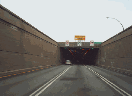
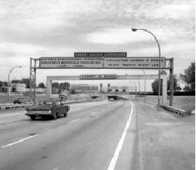
This 2005 photo shows the southbound / eastbound lanes approaching the Montreal portal of the Louis-Hippolyte Lafontaine Tunnel (A-25). (Photo by Douglas Kerr.) |
||

|
THE FIFTH CROSSING TO THE SOUTH SHORE: In anticipation of growing congestion between Montreal and the South Shore, and even as construction was well underway on the Champlain Bridge (A-10, A-15, and A-20), the Quebec government announced plans in 1960 for a new crossing further downstream along the St. Lawrence River from downtown Montreal. The proposed crossing, which was to be built and operated by the province, was to be part of a province-wide autoroute network being developed under the government of Premier Jean Lesage. |
||
|
The crossing was to be the last link in the Trans-Canada Highway, and as part of the continent-wide link was eligible for 90% federal financing with Quebec funding the remaining 10%. It was to be completed in time for Expo 67 to celebrate Canada's centennial; the world's fair was awarded to Montreal in 1962 after Moscow backed out of the competition. |
||
|
In the fall of 1962, the Ministère de la Voirie du Québec (MVQ) retained three firms (Brett & Qulett, Lalonde et Valois, and Per Hall Associates) to assume planning, engineering, and project management responsibilities. Work commenced in April 1963, although right-of-way condemnation for the A-25 northern approach in Montreal had begun two years earlier. |
||
|
The southern (eastern) approach between the Ile Charron portal and Boucherville was comprised of a 484-meter (1,500-foot)-long causeway, an interchange serving the provincial parks on Ile Charon (EXIT 1 on A-25), and an interchange with A-20 / QC 132 (former A-430) at the base of the causeway. |
||
|
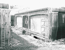
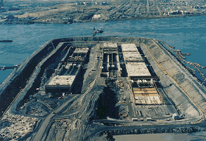
These photos from 1965-1966 show the immersed tube tunnel (ITT) sections for the Louis-Hippolyte Lafontaine Tunnel (A-25) being prepared for installation at the fabrication site on Ile Charron. (Photos © by Ministère des Transports du Québec.) |
||
|
TUNNEL DESIGN: The ITT design had two vehicular tubes each with three 12-foot-wide lanes; a service tube for tunnel employees and emergency personnel was situated between the vehicular tubes. The tunnel was built 90 feet below the low water mark of the St. Lawrence River and could accommodate a 2,400-foot-wide shipping channel. Each of the tunnel sections measured 116 meters (360 feet) long, 38.5 meters (119.5 feet) wide, and 8.1 meters (25 feet) high, and weighed about 32,000 tons. The placement of the casting basin reduced the length of the ITT sections to 813 meters (2,520 feet), and construction time and cost savings were realized. |
||
|
To provide space for the three-lane tubes, new concepts were developed for the design and construction of the tubes. Transverse pre-stressing of the roof and bottom slabs was required to resist the hydrostatic pressure for the tunnel section to be sunk into place while keeping the weight of the section within limits to provide for buoyancy to float the section into place. To counterbalance the various forces, temporary ties were installed along the bottom and roof slabs. Once the tunnel sections were lowered into place, these temporary ties were removed. |
||
|
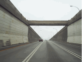
These 1970 photos show the eastbound (Montreal) and westbound (Ile Charon) portals of the Lafontaine Tunnel (A-25). (Photos from the Archives de Montréal and the Bibliothèque et Archives Nationales du Québec.) |
||
|
THE TUNNEL TODAY: According to the Ministère des Transports du Québec (MTQ), which operates and performs capital projects on the tunnel and its approaches, the Lafontaine Tunnel carries approximately 130,000 vehicles per day (AADT). Trucks are restricted to the center travel lane because of lower clearances on the left and right lanes. |
||
|
In the early 2000's, the MTQ upgraded the electrical system serving the ventilation, lighting, surveillance, and fire protection systems. From 2006 to 2008, construction crews carried out a major rehabilitation of the Ile Charron causeway approach that added a fourth southbound (eastbound) lane to A-25 for exiting traffic. In the spring and summer of 2009, the Lafontaine Tunnel was closed on the weekends so that workers could repair concrete supports for the large basins positioned at the tunnel entrances; they also made additional repairs to the ventilation and electrical systems. The MTQ expects additional weekend closures through 2014 to replace asphalt and repave the roadways. |
||
|
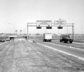
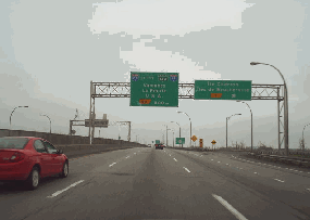
These 2005 photos shows the southbound / eastbound lanes of the Louis-Hippolyte Lafontaine Tunnel (A-25) exiting the Ile Charron portal (left photo) and at EXIT 1 on A-25 (Ile Charron / Iles de Bouchervile, right photo). (Photos by Douglas Kerr.) |
||

|
Construction started: |
||
|
April 1, 1963 |
||

|
A THIRD TUBE: Given the pending completion of the A-25 extension in October 2011 and the A-720 extension sometime in the late 2010's, it may be time to consider adding a third tube to the Lafontaine Tunnel and expanding the approaches to cope with additional congestion. However, extending A-640 north of Greater Montreal - as proposed by the Nicolet Commission - may be a more optimal solution as the northern bypass (along with the A-30 southern beltway) would remove most through traffic from Montreal Island. |
||

|
SOURCES: "Bridge-Tunnel Link Is Opened in Canada," The New York Times (3/13/1967); "Prefabricated Sections in the Construction of Underwater Tunnels," Hydrotechnical Construction (March 1969); Place Versailles Inc. v. Minister of Justice of Quebec, [1977] 2 S.C.R. 1118; Supreme Court of Canada (10/05/1976); Immersed Tunnel Techniques, Institution of Civil Engineers (1990); "Louis-Hippolyte Lafontaine Bridge-Tunnel" by RSW (Electrical Consultant), Canadian Consulting Engineer (December 2005); "Ile Charron Bridge To Get an Extra Lane," The Montreal Gazette (4/08/2006); "Montreal Tunnels Undergo Safety Inspections," Journal of Commerce (9/06/2006); "Breathing Easier in Montreal Tunnels," National Research Council Canada (February 2008); "Lafontaine Tunnel To Be Semi-Closed for Six Weekends," CTV News (4/14/2009); "Lafontaine Tunnel Closed for the Weekend," CTV News (4/17/2009); Canam Group; International Tunneling and Underground Space Association; Ministère des Transports du Québec; National Research Council Canada; Félix-Mathieu Bégin; M.J. Pierre Fortin. |
||
|
LOUIS-HIPPOLYTE LAFONTAINE BRIDGE-TUNNEL LINKS: |
||
|
LOUIS-HIPPOLYTE LAFONTAINE BRIDGE-TUNNEL CURRENT CONDITIONS: |
||

|
Jean Lesage Autoroute (A-20) Marie Victorin Autoroute (A-20 and QC 132) Ville Marie Autoroute (A-720, unbuilt) |
||

|
Back to The Crossings of Metro Montréal home page. |
||
|
Site contents © by Eastern Roads. This is not an official site run by a government agency. Recommendations provided on this site are strictly those of the author and contributors, not of any government or corporate entity. |
||