

|
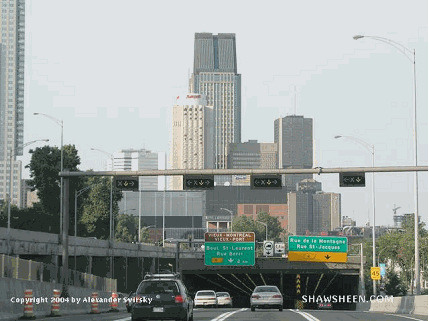
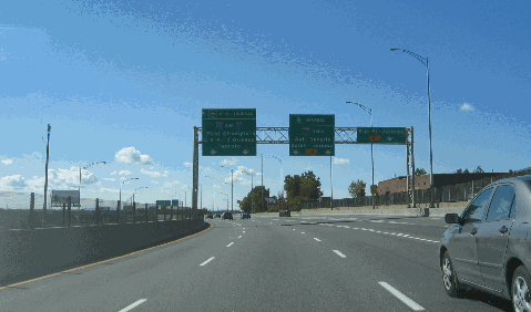
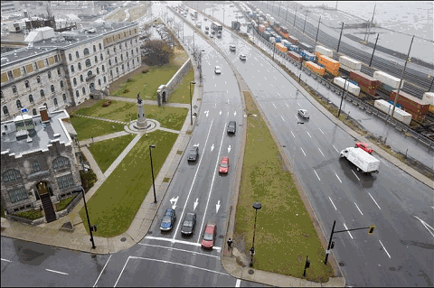
This 2004 photo shows the eastbound Ville Marie Autoroute (A-720) at EXIT 4 (De La Montagne Street / St. Jacques Street) in downtown Montreal. (Photo by Alexander Svirsky.) |
||
|
THE FIRST EXPRESSWAY TO BE MAPPED: What is known now as the Ville Marie Expressway first appeared in a 1949 traffic and mass transit study commissioned by city officials. The study called for the construction of an expressway "in an east-west direction between the river and the mountain" from the Mercier Bridge (QC 138) north and east to the Jacques Cartier Bridge (QC 134) above the CN Railroad right-of-way. A subsequent traffic study estimated a peak traffic load of 6,000 vehicles per hour for the expressway. |
||
|
As construction began on the Metropolitan Autoroute (A-40) across the spine of the island, the location of the "East-West Expressway" - as it was called originally in planning reports - remained mired in controversy. Under the original plan announced on March 24, 1960, the six-lane expressway was to be elevated along the CN right-of-way as it is today from the Turcot interchange (the junction of A-720, A-20, and A-15) to Guy Street. However, instead of tunneling under downtown as it does today, the expressway was to continue along a viaduct toward Rue de la Commune and the waterfront. One controversial part of the plan called for the demolition of historic Marche Bonsecours, creating a new urban marketplace instead underneath of the piers of the elevated roadway. |
||
|
Transitioning into downtown, the expressway was to dip south toward St. Jacques Street - where an underground interchange was planned with the Bonaventure Autoroute (A-10) - before veering back north toward an alignment along Viger Avenue. The Ville Marie extension meshed well with Drapeau's master plan to redevelop downtown from a mix of low-rise residential and mixed-used buildings to one of modern skyscrapers and sprawling plazas. |
||
|
On October 18, 1970--in the midst of Quebec's "October Crisis"--Premier Robert Bourassa announced plans to start construction of the expressway immediately, employing 4,000 workers. The initial section from the Turcot interchange to the Jacques Cartier Bridge was estimated to cost C$105 million. However, the final cost ended up totaling nearly C$500 million, including design, engineering, expropriation, and other costs, by the time this section finally was completed in 1987. |
||
|
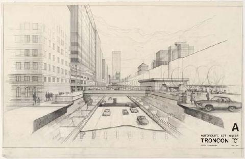
This 1968 sketch portrayed the then-proposed "East-West Expressway" built in a trench through downtown Montreal. The expressway eventually was built for the most part in a cut-and-cover tunnel. (Sketch from "Study for Section C Next to Place d'Armes, September 1968; City of Montréal, City Planning Department; from archnewsnow.com.) |
||
|
FROM TURCOT TO DOWNTOWN: As the sprawling high-level Turcot interchange between A-15 and A-20 opened in 1967, ramps were built for the eventual construction of the Ville Marie Autoroute. Following the hilly terrain of St. Henri, both carriageways of A-720 were built on split-level viaducts running about four kilometers (2.5 miles) long. The westbound lanes were built from three to six meters (about 9 to 18 feet) above the eastbound lanes, and toward the Turcot interchange the westbound lanes are cantilevered over the eastbound lanes. Construction of the elevated section began in 1970, and by November 1972 the initial three-kilometer (two-mile) section of the autoroute from the Turcot interchange to EXIT 3 (Guy Street) was opened to traffic. |
||
|
TUNNELING UNDER DOWNTOWN: The original plans for the autoroute from Guy Street through downtown called for the construction of a trench similar to that built for the Decarie Autoroute. As properties were condemned and torn down to make way for the expressway through downtown, officials decided instead to build the expressway underground from Guy Street east to Bleury Street. The tunnel was designed to reconnect and expand the downtown business district to the Old Port; it also was built to avoid disturbing Victoria Square. Construction of the tunnel required not only the closure of a number of streets, but also the realignment of tracks and platforms just west of Victoria Station (Gare Centrale). |
||
|
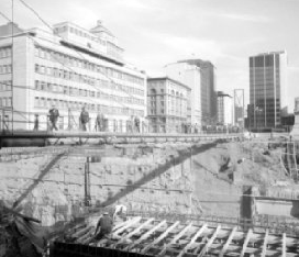
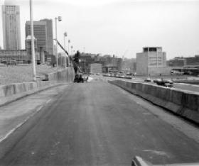
These 1972 photos show construction of the Ville Marie Autoroute (A-720) at the downtown tunnel section (left photo) and the eastbound ramp leading from EXIT 3 / Guy Street (right photo). (Photos from the Archives de Montréal and the Bibliothèque et Archives Nationales du Québec.) |
||
|
TOWARD THE CARTIER BRIDGE: The rise of Parti Québecois (PQ) after the 1976 elections, along with strident community opposition in urban areas, formally suspended many stillborn projects including the Ville Marie Autoroute through the Hochelaga and Maisonneuve neighborhoods. However, construction proceeded on extending the expressway toward the Jacques Cartier Bridge. |
||
|
In 1979, work began on building the "Viger Tunnel," an eight-lane cut-and-cover tunnel extending east from Sanguinet Street to St. Andre Street. Viger Square, a three-block-long concrete park designed by Charles Daudelin (a Canadian sculptor and landscape designer who was prominent in the brutalist movement), was built atop the tunnel. The one-kilometer (0.6-mile) long tunnel - stretching from EXIT 6 to EXIT 7 (Papineau Avenue / Jacques Cartier Bridge) was opened to traffic in 1985. |
||
|
In 1990, the Ville Marie Autoroute formally received the A-720 designation. The expressway originally had been given the A-20 designation on paper, but the road never was signed as A-20. According to the Ministere des Transports du Quebec (MTQ), A-720 carries as much as 160,000 vehicles per day (AADT), making it one of the busiest highways in the province. |
||

|
This 2006 photo shows the westbound Ville Marie Autoroute (A-720) on the elevated section at EXIT 2 (St. James Street). The Turcot interchange with A-15 and A-20 is just ahead. (Photo by Laura Siggia Anderson.) |
||
|
EXTENDING THE CONVENTION CENTER OVER A-720: In 1999, work began to double the size of the Montreal Convention Center (Palais de Congres du Montreal) to 133,000 square meters (1.43 million square feet). To accommodate the C$250 million expansion, engineers devised a plan to extend the convention hall above the Ville Marie Autoroute - which at the time was in an open trench - for a distance of 300 meters (930 feet) between Bleury and St. Urbain streets. |
||
|
The most difficult part of the project occurred between April and September 2000, when lanes were closed for the demolition of the existing center median and south support wall. A new south wall and center median wall were built to for the 21-meter (65-foot) wide beams that straddle the expressway and support the expanded convention hall. The floor of the expanded hall - which forms the roof of the expressway - was designed to support a 300-ton crane. The deck also supports a relocated fire station. |
||
|
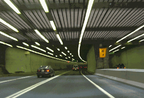
This 2007 photo shows the eastbound Ville Marie Autoroute (A-720) at EXIT 4 (Mountain Street / St. James Street) at the beginning of the Ville Marie Tunnel. (Photo by Ultima8432 from Wikipedia.) |
||

|
CLEARING THE WAY TO AUTOROUTE 25: As work began on rebuilding the Ville Marie Autoroute through downtown, the province went ahead in 1970 with acquiring rights-of-way for the extension from the Jacques Cartier Bridge (QC 134) through Hochelaga-Maisonneuve to the proposed terminus of the Ville Marie Autoroute at the Lafontaine Autoroute (A-25). A total of 1,200 homes were demolished along a nine-kilometer (5.6-mile)-long right-of-way. |
||
|
An interchange with A-25 was built in anticipation of the proposed extension. In addition, three overpasses to accommodate an eight-lane freeway were built along the Souligny Avenue right-of-way at Haig Avenue, a CFB-Montreal base access road, and Cadillac Street. (These overpasses were left unused until 1999 when the MTQ built a four-lane connection from A-25 south to Dickson Street on the Souligny Avenue right-of-way.) |
||
|
This 2007 photo shows the eastbound Notre Dame Street at Lorimier Avenue near the Montreal approach to the Jacques Cartier Bridge. The MTQ plans to expand Notre Dame Street as a landscaped urban boulevard with enhanced transit, port access, and multi-use trails. (Photo by Christopher DeWolf, www.spacingmontreal.ca.) |
||
|
REACHING A COMPROMISE FOR THE A-720 EXTENSION: On June 6, 2002, the MTQ and the City of Montreal reached a compromise on the "Rue Notre-Dame Modernization" after three years of debate at contentious public hearings. The compromise solution proposes a ground-level urban boulevard along 80% of the corridor, with the major exception a tunneled section beneath Pie-IX Boulevard and a proposed public park. From north to south, the expanded route would include a multi-use path, a landscaped embankment, a two-lane busway, an eight-meter (25-foot)-wide landscaped right-of-way, and six through-traffic lanes separated by a median strip. As in the original boulevard proposal, priority traffic lights would be placed at only a few intersections and kept at green during morning and afternoon rush hours. |
||
|
The rebuilt Notre Dame-Dickson-Souligny corridor, which could carry the A-720 designation once completed (based on the kilometer posts signed on the current "Souligny section," would be rebuilt from west to east as follows: |
||
|
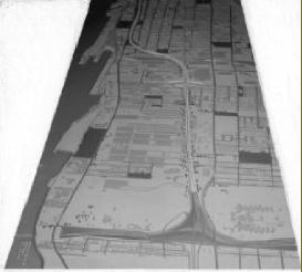
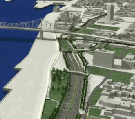
LEFT: This scale model from a 1971 presentation shows the extended Ville Marie Autoroute (then proposed as A-20) looking west (south) from the A-20 interchange and Souligny Avenue. (Photo from the Archives de Montréal and the Bibliothèque et Archives Nationales du Québec.) RIGHT: This diagram from a 2005 report shows the "modernized" Notre Dame Street (possible A-720 extension) as a landscaped boulevard heading west (south) toward the Jacques Cartier Bridge and downtown Montreal. (Diagram by Ministère des Transports du Québec.) |
||

|
REHABILITATE FIRST, THEN FINISH THE FREEWAY: The existing Ville Marie Autoroute first should be rehabilitated to address ongoing safety concerns. Once this is finished, the autoroute should be extended as a full freeway from the Jacques Cartier Bridge to A-25 and the Lafontaine Tunnel. The freeway should be capped through residential areas. If the C$750 million is going to be spent, it should not be spent on a half-solution that keeps signalized intersections and thus does not address safety and pollution concerns fully. |
||

|
SOURCES: "First Report to the Municipal Council," Montreal Board of Research on Traffic and Transportation Problems (1949); "Volume of Traffic for the Proposed Expressway System, Based on Projections for the Year 1981," Ville de Montreal, Service de la Circulation (1961); "Trans-Canada Highway Route Set" by Myer Negru, The Montreal Gazette (4/10/1964); "A Study of the Existing Montreal Expressway System" by Dominic Mignogna, McGill University (1969); "Final Report of the Public Hearings Commission on East-West Expressway," Conseil de Développement Social du Montréal Métropolitain and Montréal Council of Social Agencies (1971); Distances Routières, Ministère des Transports du Québec (1983); "The Ville Marie Expressway Is Being Built in Slow Lane" by Robert Winters, The Montreal Gazette (11/01/1986); "The Ville Marie Is Being Extended Again" by Justin Bur, Transport 2000 (Quebec) Hotline (October 1999); "City of Lost Dreams" by Kristian Gravenor, The Montreal Mirror (10/26/2000); "Quartier International: Special Planning Program for the International District," Ville de Montreal (2000); "Viger Square Transformed" by Patrick Lejtenyi, The Montreal Mirror (8/26/2004); "Modernization of Notre Dame Street," Canadian Environmental Assessment Agency (2005); "Montreal Tunnels Undergo Safety Inspections," Journal of Commerce (9/06/2006); "The Downtown Area Will Be Redrawn" by Sara Champagne, La Presse (12/09/2006); "Quebec Considers $1 Billion Plan To Rebuild Turcot Interchange," CBC News (1/12/2007); "Abandoned Turcot Rail Yards Come to Life With Creative Vision" by Andy Riga, The Montreal Gazette (2/05/2007); "Truck Ban on Ville Marie Expressway Lifted, but Lanes Still Closed," The Montreal Gazette (6/10/2007); "Pillar Cracks Need Immediate Fix" by Rene Bruemmer, The Montreal Gazette (6/11/2007); "Quebec To Demolish Crumbling Turcot" by William Marsden, The Montreal Gazette (6/29/2007); "Montreal Commuters Facing Major Expressways Tie-ups," CBC News (8/10/2007); "Structural Flaws Closes Montreal's Bleury Overpass," CBC News (9/14/2007); "Ville Marie Expressway Viable for 30 More Years, Expert Says" by Andy Riga, The Montreal Gazette (10/16/2007); "Notre Dame Street: This Time, It's for the Better" by Sebastien Rodrigue, La Presse (11/21/2007); "City, Province Abandon Their Green Trappings To Build Expressway" by Henry Aubin, The Montreal Gazette (1/31/2008); "Breathing Easier in Montreal Tunnels," National Research Council Canada (February 2008); "Notre-Dame Makeover Opponents Take to Street," CBC News (4/18/2008); "Hospital Project Not So Super, Doctors Say," The Montreal Gazette (9/18/2008); "Mayor Wants Answers on City Issues," The Montreal Gazette (11/13/2008); Project de Reconstruction du Complexe Turcot: Etude d'Impact sur l'Environment, Ministère des Transports du Quebec (2008); "Price Tag of New Superhospitals Ballooning" by Matt Chesser, The McGill Tribune (4/07/2009); "City of Montreal Voices Concern Over Rebuilding Turcot Interchange," CBC News (6/17/2009); Félix-Mathieu Bégin; Christopher DeWolf; Richard Dupuis. |
||
|
VILLE MARIE AUTOROUTE LINKS: |
||
|
VILLE MARIE AUTOROUTE VIDEO LINKS: |
||
|
VILLE MARIE AUTOROUTE CURENT CONDITIONS: |
||
|
OFF-SITE EXIT LISTINGS: |
||
|
VIEW OR SUBMIT YOUR RATING TO RATETHEROADS.COM: |
||
|
|
||
|
Back to The Roads of Metro Montréal home page. |
||
|
Site contents © by Eastern Roads. This is not an official site run by a government agency. Recommendations provided on this site are strictly those of the author and contributors, not of any government or corporate entity. |
||