
|
|
||
|
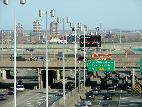
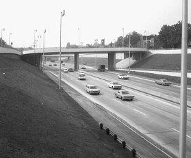
This 2005 photo shows the southbound Decarie Autoroute (A-15) approaching EXIT 63 (A-720 / Ville Marie Autoroute and A-20 / Montreal-Toronto Autoroute). The sprawling Turcot interchange shown here was completed in 1967 over the CN Turcot rail yard. (Photo by Christopher DeWolf, www.urbanphoto.net.) |
||
|
Length: |
||
|
11.6 kilometers (7.2 miles) |
||
|
A ROUTE "MOST URGENTLY NEEDED": Even before the last streetcar rolled down Decarie Boulevard in 1959, city planners in Montreal developed plans for a network of expressways crossing Montreal Island. One of the proposed routes was along Decarie Boulevard, which was named after one of Montreal's prominent families that settled in Notre-Dame-du-Grace and Cote-St.-Luc beginning in the 1700's. Decarie Boulevard played a prominent role in the development of Montreal's "streetcar suburbs" in the first decades of the 20th century. |
||
|
The proposed Decarie Expressway was to connect the Champlain Bridge (A-10, A-15, and A-20) with the Metropolitan Autoroute (A-40), both of which already were under construction when plans were announced. When the city's traffic agency released its final study in 1961, it advocated construction of new expressways along Papineau Avenue, Lafontaine Avenue, and the Canadian National (CN) Railroad-St. Lawrence riverfront alignment, in addition to the Decarie and Metropolitan Expressways. However, the report said the Decarie Expressway was "most urgently needed" as it was expected to handle a peak of 90,000 vehicles per day (AADT) by 1981. |
||
|
By the time the study was released, work already had begun on a six-lane approach connecting the Champlain Bridge with Atwater Avenue (EXIT 61) and La Verendrye Boulevard (EXIT 62); this section was built not by the city or the province, but under the Crown as part of the Champlain Bridge project. This section, which was built almost entirely as a viaduct and opened to traffic in 1963 (one year after the bridge), was not built to modern expressway standards and is noted by its sharp curves, lack of shoulders, and lack of full acceleration-deceleration lanes. This section is signed dually as A-15 and A-20. |
||
|
Even at this late date, the fate of the Decarie Expressway was uncertain. Some city council members, fearful of inciting vote among residents and businesses along the route, suggested rebuilding the existing Decarie Boulevard in a scaled-down C$18 million project, while others suggested a new Metro subway line along Decarie Boulevard. |
||
|
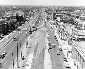
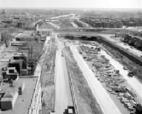
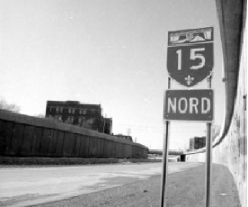
FROM STREETCARS TO EXPRESSWAY... (1) UPPER LEFT: Decarie Boulevard in 1961, two years after the last streetcar rolled down the boulevard. (2) UPPER RIGHT: This 1966 photo shows the depressed Decarie Autoroute under construction. (3) LOWER LEFT: A newly installed A-15 sign awaits completion of the expressway in this 1967 photo. (4) LOWER RIGHT: This 1968 photo shows the Decarie Autoroute looking north at the U-turn overpass leading from southbound EXIT 64 (Chemin de la St.-Antoine). (Photos from the Archives de Montréal and the Bibliothèque et Archives Nationales du Québec.) |
||
|
A RACE AGAINST THE CLOCK: With a deadline of completion of April 1967--the month that Expo '67 was to open--demolitions along the expressway route began in earnest in 1964 and construction began the following March. The Decarie right-of-way was expanded to accommodate a six-lane expressway and one-way service roads. Along the southern half of the route, grassy berms separated the express roadways and service roads; in the northern half, concrete walls separated the expressway and service roads. |
||
|
Borrowing from a popular mid-century urban expressway design, the express lanes were depressed 7 to 8 meters (22 to 25 feet) below street level to minimize noise and visual impact. Construction crews trucked fill from the excavations for the expressway to expand Ile-Notre-Dame and Ile-Ste.-Helene, the site of Expo '67. |
||
|
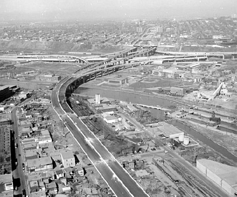
This 1967 photo shows the Turcot interchange nearing completion as seen looking north from the "Champlain Viaduct" section of the Decarie Autoroute shared by A-15 and A-20. (Photo from the Bibliothèque et Archives Nationales du Québec.) |
||
|
REBUILDING THE DECARIE: In 2000, the Ministere des Transports du Quebec (MTQ) began a three-year project to rebuild all 27 overpasses and repair concrete walls along 5.2 kilometers (3.2 miles) of the Decarie Expressway between the Turcot Interchange and the Decarie Circle. This project took on an added sense of urgency when a section of overpass collapsed onto the Laurentian Autoroute (A-15) in Laval in June of that year. The C$33 million project, which the MTQ had contracted out to Toronto-based Aecon Group, was completed in 2002. |
||
|
A NEW RAMP FOR THE MUHC COMPLEX: In 2006, the MTQ built a new ramp from the southbound Decarie Expressway for Maissoneuve Boulevard. The new ramp is designed to serve the McGill University Hospital Centre (MUHC), the so-called "super-hospital" built on the grounds of the Canadian Pacific (CP) Railroad's former Glen Railyards just north of the Turcot Interchange. The southbound ramp, which is designated EXIT 64A, was opened in 2014 after years of delay. Nearby, the $2 billion MUHC complex opened its doors in 2015. |
||
|
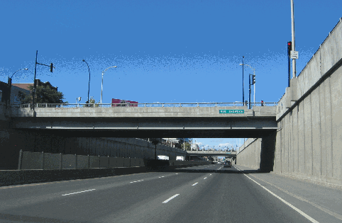
This 2006 photo shows the depressed Decarie Autoroute (A-15) looking north at Snowdon Street. Although rehabilitated in the early 2000s, this section has been the subject of a more extensive rebuilding option, one that would place a cover on the depressed section. (Photo by Laura Siggia Anderson.) |
||

|
A DIRECT CONNECTION TO THE LAURENTIAN AUTOROUTE: As far back as the 1960s, a number of proposals have been floated to extend the Decarie Expressway north to the Laurentian Autoroute (A-15). This extension would avoid a congested three-kilometer (two-mile) stretch of A-40 on which A-15 travelers must traverse in order to connect to the Decarie Expressway and the Laurentian Autoroute. (Local traffic reporters call this section of the Metropolitan Expressway "between the two 15s.") |
||
|
One more recent proposal to connect "the two 15s" has involved building a six-lane tunnel along Decarie Boulevard north of the Metropolitan Expressway in order to minimize community disruption. With most of the province's resources focused now on rebuilding the nearly half-century-old autoroute network, it is unlikely that this project will be built. If the "Decarie Extension" were to be built, however, the existing Laurentian Autoroute immediately north of A-40 conceivably would be closed and converted into parkland. |
||

|
SOURCES: Decarie Expressway, City of Montreal: Preliminary Report, Lalonde, Girouard, Letendre & Associates (1959); "Volume of Traffic for the Proposed Expressway System, Based on Projections for the Year 1981," Ville de Montreal, Service de la Circulation (1961); "A Study of the Existing Montreal Expressway System" by Dominic Mignogna, McGill University (1969); Distances Routières, Ministère des Transports du Québec (1983); "Bury the Decarie" by Kristian Gravenor, The Montreal Mirror (3/04/1999); "Decarie Under Construction," CBC News (6/26/2000); A Shared Vision for Action: Planning Framework and Government Orientations, Montreal Metropolitan Region 2001-2021, Ministère des Affaires Municipales et de la Metropole (2001); Southern Decarie Design Brief by Pierre Gauthier, Concordia University-Urban Studies Programme (2002); "Quebec Considers $1 Billion Plan To Rebuild Turcot Interchange," CBC News (1/12/2007); "Abandoned Turcot Rail Yards Come to Life With Creative Vision" by Andy Riga, The Montreal Gazette (2/05/2007); Project de Reconstruction du Complexe Turcot: Etude d'Impact sur l'Environment, Ministère des Transports du Quebec (2008); "Price Tag of New Superhospitals Ballooning" by Matt Chesser, The McGill Tribune (4/07/2009); "City of Montreal Voices Concern Over Rebuilding Turcot Interchange," CBC News (6/17/2009); "New Decarie Exit Ramp Opened, Shortcut Returned," CTV News (8/26/2014); "Quebec Signs $1.54B Contract To Replace Turcot Interchange" by Jason Magder, The Montreal Gazette (2/27/2015); "New Phase of Turcot Work Leads to Long-Term Road Closures" by Annabelle Olivier, Global News (9/26/2017); Aecon Group; Armbro Enterprises, Inc.; Félix-Mathieu Bégin; Christopher DeWolf; Richard Dupuis. |
||
|
DECARIE EXPRESSWAY LINKS: |
||
|
DECARIE EXPRESSWAY CURENT TRAFFIC CONDITIONS: |
||
|
DECARIE EXPRESSWAY VIDEO LINKS: |
||
|
THE EXITS OF METRO MONTREAL: |
||
|
|
||
|
Back to The Roads of Metro Montréal home page. |
||
|
Site contents © by Eastern Roads. This is not an official site run by a government agency. Recommendations provided on this site are strictly those of the author and contributors, not of any government or corporate entity. |
||