
|
|
||
|
This 2013 photo shows the northbound Lafontaine Expressway (A-25) at EXIT 4 (Souligny Avenue). This interchange was to built as the intended eastern terminus of the Ville Marie Expressway (A-720 / QC 136) in the 1960s, but the extension of the Ville Marie Expressway was canceled. Construction is now underway to accommodate three travel lanes of A-25 through the "Souligny interchange" in each direction as part of the C$2.2 billion reconstruction project, (Photo by Steve Anderson.) |
||
|
Length: |
||
|
16.4 kilometers (10.2 miles); measured from A-20 junction in Boucherville to A-440 junction in Laval |
||
|
Olivier Charbonneau Bridge: |
||
|
With Transponder: |
||
|
C$2.96 (off-peak) |
||

|
PLANNING A TUNNEL APPROACH: The Lafontaine Expressway had its genesis in the planning for a northerly bypass of urbanized Montreal via the Trans-Canada Highway. On October 27, 1960, newly-elected Premier Jean Lesage reached an agreement with the federal government that finalized the routing of the transcontinental route through Quebec. The Trans-Canada Highway was to be routed east-west through Montreal along the Metropolitan Expressway (A-40). To the east, the Trans-Canada Highway was to connect to Route 9 (today's QC 116) near Sainte-Hyacinthe. This necessitated construction of a new autoroute link in the eastern part of the city of Montreal. |
||
|
The provincial government began studies on possible alignments in 1961. It studied three alternate alignments for the St. Lawrence crossing and approaches as follows: |
||
|
|
||
|
SELECTING A ROUTE: Planners finally decided on a fourth alignment from the Longue-Pointe neighborhood in Montreal to Longueuil. To the west, there was a buffer zone through the area of Saint-Jean-de-Dieu Psychiatric Hospital (now the CIUSSS de l'Est-de-l'Île-de-Montréal campus) that was almost uninterrupted from the Metropolitan Expressway east to the St. Lawrence River, providing a desirable approach for the expressway and river crossing. To the east, the Longueuil approach provided a direct connection toward Sainte-Hyacinte and (eventually) Quebec City. The alignment also provided a development opportunity for the Port of Montreal, which had plans to extend northward and eastward. Furthermore, this alignment allowed for the use of the Boucherville Islands to be used as a construction staging area, which reduced construction costs and disruptions. |
||
|
This 1970 photo shows the interchange between the Lafontaine Expressway (A-25) and Souligny Avenue. A-25 was to join an extended Ville Marie Expressway at this location. (Photo from the Archives de Montréal and the Bibliothèque et Archives Nationales du Québec.) |
||
|
EXPRESSWAY DESIGN: Except for the freeway-to-freeway interchanges at EXIT 4 (Souligny Avenue) and EXIT 8 (A-40 / Metropolitan Expressway), where there are two through lanes in each direction for A-25 traffic, the Lafontaine Expressway was designed with three lanes in each direction. It was planned as one of four north-south freeway axes in the city of Montreal, along with A-13 (Chomedey Expressway), A-15 (Decarie Expressway / Laurentian Autoroute), and A-19 (Papineau Expressway, only a small portion of which was built in Montreal). It was built mostly as a depressed route with flanking one-way service roads to serve local traffic, except through the areas of EXIT 4 and EXIT 8, where complex freeway-to-freeway interchanges interrupted the service roads. |
||
|
The first section of the Lafontaine Expressway opened in 1966 from EXIT 4 north to EXIT 9 (Bombardier Street), just north of the Anjou interchange with A-40. This was followed in March 1967 with the opening of the Lafontaine Bridge-Tunnel, as well as the immediate expressway connections from EXIT 4 south to the A-20 / A-25 / QC 132 interchange in Boucherville. Importantly, the expressway bypass to the immediate north and east of Downtown Montreal--formed by the combination of the Lafontaine and Metropolitan Expressways was completed in time for the opening of Expo 67 the following month. The new Lafontaine Expressway was given the A-25 designation upon opening. |
||
|
The rebuilt Pie-IX bridge and freeway conversion of Pie-IX Boulevard completed in 1967, and four years later, the freeway was extended from Pie-IX to Terrebonne. However, this was meant to be a temporary designation, as short section of the Pie-IX freeway (today's QC 125), along with a five-kilometer (three-mile)-long stretch of the Laval Expressway (today's A-440), were given the "Temporary A-25" designation. |
||
|
Provincial maps dating back to the late 1960s had envisioned a more direct route from Terrebonne to the Lafontaine Tunnel, but the route was not considered an immediate priority as the province turned its attention to its major east-west axes (A-20 and A-40), the construction of an autoroute toward Mirabel Airport (A-13), and some ring roads around Montreal and Quebec City. Moreover, some local officials and environmentalists feared the loss of farmland in eastern Laval (Ile Jesus). |
||
|
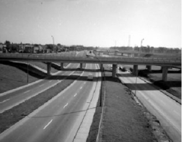
This 2006 photo shows the southbound Lafontaine Expressway at EXIT 8 (A-40 / Metropolitan Expressway / "Anjou interchange") in eastern Montreal. When this photo was taken, this section of the expressway was a stub route north of A-40 that did not have a designation. (Photo by Laura Siggia-Anderson.) |
||

|
AFTER A FALSE START, SOME PROGRESS: In 1972, the Ministere de la Voirie du Quebec (MVQ) announced plans for a new A-25 alignment between the Anjou interchange (A-40) in Montreal and the existing A-25 alignment at Montee Masson (QC 125) in Laval. Soon after the announcement, the province began depth soundings along Riviere des Prairies in the area of the proposed A-25 crossing. Ultimately, this announcement proved a false start, even as work continued to extend A-25 north toward the Lanaudiere region. |
||
|
A couple of new obstacles faced the A-25 "missing link" project in the second half of the 1970s. First, the newly elected Parti Quebecois implemented an eight-year moratorium on new autoroute construction in the province, with work limited to autoroutes that already were under construction. Second, Quebec became the first province to implement environmental review studies in 1978, through what is now known as a BAPE (Bureau d'audiences publiques sur l'environnement) study. New infrastructure projects in the province now had to undergo rigorous environmental studies as part of the planning process. |
||
|
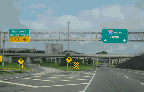
This 2013 photo shows the northbound Lafontaine Expressway (A-25) at EXIT 10 (Henri-Bourassa Boulevard) in eastern Montreal. This was part of a short extension north of A-40 that opened in 2002. EXIT 10 is the last northbound exit before the electronic toll gantry for the Olivier Charbonneau Bridge. (Photo by Steve Anderson.) |
||
|
REBUILDING THE LAFONTAINE TUNNEL AND APPROACHES: In 2017, the province announced a major C$1.4 billion reconstruction of the Lafontaine Tunnel and its approaches. In addition to rehabilitating the tunnel superstructure, and upgrading the electrical and fire protection systems, the province is rebuilding five kilometers (three miles) of A-25 on both sides of the tunnel from A-20 in Longueuil to EXIT 5 (QC 138 / Sherbrooke Street). |
||
|
The key improvement to the northern A-25 approach is the reconstruction of EXIT 4 (Souligny Avenue), at which three through lanes will be provided in each direction, up from the pre-construction two lanes in each direction. Additional work at the interchange includes the replacement of ramps and flyover structures and the installation of sound barriers. |
||
|
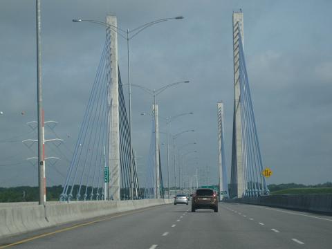
This 2013 photo shows the northbound Lafontaine Expressway (A-25) at the Oliver Charbonneau Bridge. Completed in 2011, the bridge carries A-25 across the Riviere des Prairies between Montreal and Laval. (Photo by Steve Anderson.) |
||

|
SOURCES: Prolongement de l'Autoroute 25 Entre l'Autoroute 440 et le Boulevard Henri-Bourassa: Rapport d'Analyse des Impacts; Ministere des Transports du Quebec (2001); "A Coalition Against the Extension of Highway 25" by Louis-Gilles Francoeur, Le Devoir (2/10/2005); "$1 Billion Highway Extension a Step Closer to Reality" by Irwin Rapoport, Daily Commercial News (11/16/2006); Autoroute 25: Request for Proposals, Ministere des Transports du Queb ec (2006); "Quebec Sets Toll Limits for the Proposed Laval Bridge," The Montreal Gazette (6/11/2007); "A Bit of History: Autoroute 25," La Revue (1/09/2015); "Lafontaine Tunnel To Undergo $1B in Renovations Starting in 2019;" CKMI-TV (6/28/2017); "Canada's Busiest Highway Tunnel Gets $1.4B Upgrade," Daily Commercial News (ConstructConnect.com) (4/14/2022); "Louis-Hippolye-Lafontaine Tunnel Work To Last Until 2025" by Brendan Kelly, The Montreal Gazette (8/04/2022); "Lafontaine Tunnel Renovation Costs Increase by $1 Billion," The Montreal Gazette (3/21/2023); CIMA; Scott Steeves. |
||
|
LAFONTAINE EXPRESSWAY LINKS: |
||
|
LAFONTAINE EXPRESSWAY CURENT TRAFFIC CONDITIONS: |
||
|
LAFONTAINE EXPRESSWAY VIDEO LINKS: |
||
|
THE EXITS OF METRO MONTREAL: |
||

|
|
||

|
Back to The Roads of Metro Montréal home page. |
||
|
Site contents © by Eastern Roads. This is not an official site run by a government agency. Recommendations provided on this site are strictly those of the author and contributors, not of any government or corporate entity. |
||