

|
This 2006 photo shows the main cantilever span of the Jacques Cartier Bridge (QC 134) from the intersection of Lorimier Avenue and Viger Avenue in Montreal. (Photo by Laura Siggia Anderson.) |
||

|
RELIEVING CONGESTION ON THE VICTORIA BRIDGE: As early as 1874, officials in Montreal and surrounding communities petitioned for a new bridge across the St. Lawrence River to relieve congestion on the Victoria Bridge. Unlike the Victoria Bridge, which handled rail traffic exclusively at the time, the proposed span was to handle railroad, horse, carriage, and pedestrian traffic. One of the engineers who designed the Victoria Bridge, Charles Legge, even drew up preliminary plans for the bridge. This proposal ultimately proved the first among a series of failed bridge plans during the next 35 years. |
||
|
Meanwhile, congestion continued to build on both sides of the St. Lawrence. Two ferries connecting Montreal and Longueuil provided some relief during the summer months, while an "ice bridge" provided access during the winter. However, none of these solutions provided adequate all-weather relief, and in the case of the "ice bridge," a safe crossing. |
||
|
In November 1924, the Commissioners awarded the engineering contract to the "Montsarrat, Pratley and Strauss" joint venture, which comprised of Montsarrat and Pratley of Montreal, and J.B. Strauss of Chicago. |
||
|
The Dominion Bridge Company won the C$7 million contract to build the superstructure, while two construction companies - Quinlan, Robertson, and Janin; and Dufresne Construction - split the $1.1 million contract for the piers and approaches. Officials broke ground for the new "Montreal Harbour Bridge" on May 26, 1925, just four days after the first contract was awarded, and construction began at the Montreal and Longueuil job sites the following day. |
||

|
This photo shows the dedication of the Jacques Cartier Bridge in 1930. The span was known as the "Montreal Harbor Bridge" until it was renamed after the French explorer in 1934. (Photo from the Bibliotheque Nationale de Quebec archives.) |
||
|
THE CENTER PAVILION AT ILE STE.-HELENE: At the center of the bridge on Ile Ste.-Helene, there is a three-story building underneath the bridge (measuring 71.6 meters, or 235 feet in length) that is used today for maintenance operations. Part of the central support for the bridge, the pavilion was planned originally to be used as a casino, but it was turned into a reception hall after Roman Catholic Church officials opposed the casino. A helix-style access ramp was built as part of the original design from the south side of the bridge (at the pavilion) to the island. |
||
|
SUPPORTING SPANS: The bridge's other spans are described as follows: |
||

|
This 2006 photo shows the Warren truss span of the Jacques Cartier Bridge (QC 134) from Ile Ste-Helene. The truss span and its immediate approaches were raised in the late 1950's in advance of construction of the St. Lawrence Seaway. (Photo by Laura Siggia Anderson.) |
||
|
A NEW NAME TO HONOR A GREAT EXPLORER: On September 1, 1934, the Commissioners renamed the Montreal Harbour span officially in honor of Jacques Cartier on the 400th anniversary of the French explorer's discovery of Canada. At the re-dedication ceremony for the "Jacques Cartier Bridge," the Governor of France presented Canada with a bust of Jacques Cartier, which was placed at the current location of the westbound ramps to Ile Ste.-Helene. The bust was moved to a wall of the Ile Ste.-Helene pavilion in 1962. |
||
|
BUILT FOR THE AUTOMOBILE AGE
When it opened to traffic in 1930, the bridge had three inner lanes reserved for vehicular traffic and two lanes reserved for streetcar traffic. There was a 40 km/h (25 MPH) speed limit on the bridge, and passing was prohibited. |
||
|
During the 1960's, highway officials in Montreal and Quebec had more ambitious plans for the Jacques Cartier Bridge approaches. To the south and east, the province had plans to extend the bridge approach toward a new Wilfrid-Laurier Autoroute (proposed A-16) in Longueuil. To the north and west, officials planned to build a depressed Papineau Autoroute across Montreal Island toward Laval; the proposed six-lane A-19 extension was to have a similar design to the Decarie Autoroute (A-15). Construction of the new A-16 and extended A-19 to the bridge likely would have resulted in more severe congestion, possibly requiring the construction of either a twin span or a larger replacement span. |
||
|
AND LATER FOR THE SEAWAY: During the 1957 and 1958 construction seasons, workers jacked up the Warren truss over the east channel of the St. Lawrence River, as well as raised the profile of the bridge on either side of the Warren truss. The C$6.7 million project, which was awarded to Dominion Bridge Company under the supervision of consulting engineer Philip L. Pratley, raised the clearance underneath the Warren truss to 120 feet (from the previous 40 feet). |
||

|
This photo from the early 2000's shows deck replacement work underway on the Jacques Cartier Bridge. (Photo by Federal Highway Administration, US Department of Transportation.) |
||
|
TOLL IRREGULARITIES EVENTUALLY LEAD TO THEIR REMOVAL: On September 8, 1959, the National Harbours Board completed the installation of electronic toll collection in order to ease congestion on the bridge. In the months following the conversion, officials noted an unusual spike in amount of toll revenue, leading them to believe that toll collectors pilfered collections over the years. This led to a February 1960 raid of former and then-current toll collectors at their homes. On June 1, 1962, less than three years after the toll collection machines were introduced, the National Harbours Board removed tolls from the Jacques Cartier Bridge. |
||
|
In 1978, the Jacques Cartier and Champlain Bridges Incorporated (JCCBI) assumed control of the Jacques Cartier Bridge from the former National Harbours Board. |
||

|
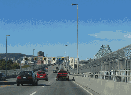
This 2006 photo shows the Jacques Cartier Bridge heading west toward Montreal. Note that the center lane is kept clear during non-peak travel periods through the electronic lane control system. (Photo by Laura Siggia Anderson.) |
||

|
A NEW "ZIPPER" BARRIER: A concrete "zipper" barrier should be used on the roadway to eliminate the incidence of head-on collisions. Similar barriers are used on New York's Tappan Zee Bridge (I-87 and I-287), Philadelphia's Betsy Ross (NJ 90) and Commodore Barry (US 322) bridges, and Boston's Southeast Expressway (I-93) to control traffic flows and provide flexible use of lane capacity while increasing safety. |
||
|
PART OF A NEW A-16: The Jacques Cartier Bridge should become part of a new Autoroute 16 that would begin at an extended Ville Marie Autoroute (A-720), where new ramps would be built. Upon crossing the bridge into Longueuil, A-16 would extend along the existing autoroute sections of Taschereau Boulevard (QC 134) and Wilfrid-Laurier Boulevard (QC 116). Just east of A-30 (De L'Acier Autoroute), A-16 would depart from QC 116 and extend east on new right-of-way to QC 227 / QC 229 in St.-Jean-Baptiste. |
||

|
Type of bridge: |
||
|
Cantilever and through-truss |
||

|
SOURCES: "$20 Million Montreal Bridge Route for American Tourists," The New York Times (4/20/1930); "New Span in One Day," The New York Times (10/18/1957); "Philip Pratley, 73, A Bridge Designer," The New York Times (8/02/1958); "Boom in Highways Buoys Montreal As Suburbs Grow" by Charles J. Lazarus, The New York Times (1/14/1959); "Toll-Takers Raided," The New York Times (2/10/1960); "Montreal Already Looking to Its World's Fair" by Charles J. Lazarus, The New York Times (7/19/1964); "A Study of the Existing Montreal Expressway System" by Dominic Mignogna, McGill University (1969); "Transport Management Plan, Greater Montreal Area," Transport Quebec (2000); "On Your Side: Jacques Cartier Bridge Suicides," CFCF-TV (12/03/2003); "Jacques Cartier Bridge Re-decking Project," Transportation Association of Canada (2003); "NCHRP Synthesis 324: Prefabricated Bridge Elements and Systems To Limit Traffic Disruption During Construction," Transportation Research Board (2003); Federal Bridge Corporation; Federal Highway Administration; Jacques Cartier and Champlain Bridges Incorporated; Transport Canada; Transport Quebec. |
||
|
JACQUES CARTIER BRIDGE LINKS: |
||
|
JACQUES CARTIER BRIDGE VIDEO LINK: |
||
|
JACQUES CARTIER BRIDGE CURRENT CONDITIONS: |
||

|
Papineau Autoroute (A-19) Marie Victorin Autoroute (A-20) Wilfrid Laurier Autoroute (QC 116) |
||

|
Back to The Crossings of Metro Montréal home page. |
||
|
Site contents © by Eastern Roads. This is not an official site run by a government agency. Recommendations provided on this site are strictly those of the author and contributors, not of any government or corporate entity. |
||